|
||

|

|
|

|
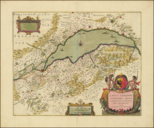
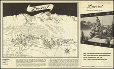
Le Canton de Neuchâtel provides an exquisite portrayal of the canton's geographical variety, historical richness, and cultural vibrancy, framed within the scenic beauty of French-speaking Switzerland.
This dual-sided English language map and brochure invites explorers and enthusiasts alike to delve into the heart of Neuchâtel, offering a panoramic view of its landscapes, from the tranquil Lake Neuchâtel to the majestic Jura Mountains, coupled with immersive narratives on local traditions and intellectual pursuits.
The Neuchâtel region, steeped in a history that transitions from ancient Celtic settlements to a Prussian principality before becoming a quintessential part of the Swiss Confederation, is presented through engaging cartographic detail and narrative. The brochure artfully combines historical insights with the natural allure of the region, catering to those who appreciate the intricate melding of history with geography, highlighting the area's evolution and its present-day cultural significance.
The panoramic map offers a vibrant depiction of Neuchâtel’s topography, landmarks, and transportation routes. Accompanying illustrations and annotations provide a rich tapestry of information, making the brochure an invaluable tool for geographers, nature enthusiasts, and those fascinated by the picturesque landscapes of Switzerland. This section emphasizes the region’s natural wonders and scenic diversity, inviting visitors to experience the tranquility and beauty firsthand.
Finally, the brochure acts as a comprehensive travel guide, offering detailed information on Neuchâtel’s tourist attractions, leisure activities, and accommodations. It encapsulates the essence of the canton as a destination for diverse interests – from outdoor adventures and historical tours to relaxation and culinary exploration.