|
||

|

|
|

|
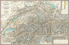
This 1768 map, Canton Zug sive Pagus Helvetiae Tugiensis cum Confinibus, offers a detailed representation of the Canton of Zug in Switzerland, known for its strategic geographical location in the confederation.
During this period, the canton was an integral part of the Old Swiss Confederacy, an entity marked by a confederate structure that balanced local autonomy with collective governance. The map illustrates the canton's lakes, such as the Zugersee and the Ägerisee, and its mountain ranges, including the Rigi and the Zugerberg, that define the region's topography. The delineation of these natural features provides insights into the environmental challenges and resources available to the local inhabitants at the time.
Zug's major towns, including Baar, Cham, and the cantonal capital Zug, are clearly marked, indicative of their prominence. These urban centers were instrumental in the administration and economic life of the canton. The capital's role as a central node is particularly evident, situated on the northeastern shore of the Zugersee, benefiting from both the trade routes crossing central Switzerland and the fertile lands surrounding it.
Homann Heirs was a German publishing firm that enjoyed a major place in the European map market throughout the eighteenth century. Founded in 1702 by Johann Baptist Homann, the business passed to his son, Christoph, upon Johann’s death in 1724. Christoph died in 1730, aged only 27, and the firm was inherited by subsequent Homann heirs. This altered the name of the company, which was known as Homann Erben, or Homann heirs. The firm continued in business until 1848.
Gabriel Walser he began his theology studies in Basel in 1712, and, after study visits in Marburg, Tübingen, Jena, and Halle, he completed his examination there in 1717. He became a member of the Appenzell Synod. In 1718, he married Maria Elisabeth Zollikofer, who hailed from a noble St. Gallen family and was the daughter of Ruprecht Zollikofer. In 1721, he was elected as the pastor of Speicher, where he served from 1721 to 1745. In the land trade, he took the side of the defeated Lindens and was thus fined in 1732. In 1745, he took up the pastoral position in Berneck, which he held until his death.
In addition to his duties as a pastor, Gabriel Walser wrote the "Old and New Appenzeller Writing Calendar" for the years 1738 to 1745, a collection with easy-to-understand scientific, historical, and narrative content.
His main work was the "Neue Appenzeller-Chronick or Description of the Canton of Appenzell of the Inner and Outer Rooden", self-published in 1740. This history of the Canton since Roman times also included geographic descriptions, including a map of Appenzell. It contained an appendix with various documents from the years 1378 to 1667 and an official directory. Walser's chronicle is considered an extension and continuation of the Appenzell Chronicle of the pastor Bartholomäus Bischofberger from Trogen, which goes up to the year 1682. The more valuable, regional part of the chronicle is based on his observations. The historical part connects to Bartholomäus Bischofberger's work and supplements it up to 1732. His continuation for the years 1732 to 1772 was only published in 1829.
For the Augsburg publisher Matthaeus Seutter, Walser created maps of the cantons Lucerne, Uri, Schwyz, Glarus, and Appenzell as well as Graubünden, after numerous trips through eastern and central Switzerland. For the "Atlas Novus Reipublicae Helveticae", published in Nuremberg in 1769, he created,15 maps covering 18 cantons covering the 18 cantons of the Old Confederacy (excluding Schaffhausen) and the territories of St. Gallen, Graubünden, and Wallis, based on maps by Johann Jakob Scheuchzer, Hans Konrad Gyger, and others,from 1763 to 1768. Walser did not carry out any surveys for this. However, his maps represent a slight qualitative improvement compared to Scheuchzer's maps. In 1770, Walser's "Swiss Geography with the Sights in the Alps and High Mountains" was published in Zurich. This is an explanation of the atlas.
![[Premier Hotels in Swizterland] Hotels de tout Premier Rang de Suisse](https://storage.googleapis.com/raremaps/img/small/87442.jpg)