|
||

|

|
|

|
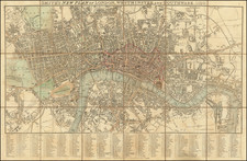
Detailed plan of London and Westminster, published in London in 1764.
The 1764 map by J. Gibson delineates the significant urban expansion of London, Westminster, and the Borough of Southwark. During the 18th century, London experienced considerable growth, a fact which is meticulously recorded in Gibbs' survey.
In the City of London, the area within the original Roman walls remained largely unchanged, with its medieval street pattern still recognizable. However, the neighborhoods around it saw extensive development. To the west, areas such as Mayfair began development in the early 1700s, with completion around the 1760s, offering a glimpse into the residential growth of the period. St. James's, developed predominantly in the late 17th and early 18th centuries, is also featured, displaying its status as an aristocratic enclave.
Westminster, already established as the political center, continued to grow with the addition of new administrative buildings. The areas around Covent Garden, developed since the mid-17th century, and Soho, laid out in the late 17th century, are more densely plotted, signaling their transformation into commercial and residential districts.
To the east, the docklands area reflects the commercial growth due to trade, with development of infrastructure like Limehouse Dock and St. Katharine Docks occurring in the early 18th century. Beyond the city's core, the map shows the suburban growth into areas like Spitalfields and Whitechapel, which had been urbanized since the late 17th century.
South of the Thames, in the Borough of Southwark, the map reveals significant development, with the area transitioning from a more rural landscape to an urban one. This is evidenced by the depiction of roads and buildings in what had been open fields just decades earlier.
The new roads and buildings marked as "New Buildings Roads" on the map suggest further expansion beyond the traditional city limits. The development of squares and residential areas outside of the old city boundaries reflected the demographic and economic shifts of the time.
This map serves as a detailed historical record, pinpointing the evolution of London's neighborhoods throughout the 18th century. It highlights the city's adaptation to demographic pressures and economic opportunities, charting its growth from a medieval cityscape into a complex urban center by 1764.
John Gibson flourished in London from 1748 to 1773. He was most likely born ca. 1724. As a young man he was apprenticed to John Blunbell of the Stationers Company, and then to John Pine. He was made free of the Company in 1748. Gibson proved a talented geographer and engraver who produced numerous maps, especially for books and magazines. He worked in collaboration with other map sellers such as Emanuel Bowen and John Roque. His best-known work was the pocket atlas, The Atlas Minimus (1758). Although little is known about his life beyond his publications, he was imprisoned for debt in King’s Bench from May to June of 1765.
![[Suburbs of London] Sheet 1: Bayswater, Notting Hill, Kensal Green, Shepherds Bush &c. [with] Sheet 2: Greenwich &c. [and] Sheet 3: Bromley, Blackwall &c.](https://storage.googleapis.com/raremaps/img/small/80967.jpg)
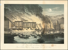
![The Tower of London, As Seen October 31st 1841 [the morning after the fire]](https://storage.googleapis.com/raremaps/img/small/92003.jpg)