|
||

|

|
|

|
Stock# 91997
Description
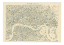
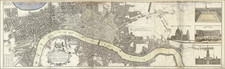
Fine, original, antique map of London as it stood in 1926, showing fine, city block-level detail.
The map shows the West India Docks, the East India Docks, and other features in the Isle of Dogs and Canary Wharf. Southwark is developing further south, and Greenwich is shown. Westward, the map extends to Hyde Park, Regent's Park, Chelsea, and Kensington.
Below the map, an extensive listing of 100s of streets in London is given.
Condition Description
Folding map with slipcover.
![[ London ] An Exact Survey of the City's of London Westminster ye Borough of Southwark and the Country Near Ten Miles Round Begun In 1741 & Ended in 1745 By John Rocque Land Surveyor & Engrau'd By Richard Parr / A New and Accurate Survey Of the Cities of London and Westminster The Borough of Southwark with The Country about it for nineteen Miles in Length and thirteen in Depth . . .](https://storage.googleapis.com/raremaps/img/small/96431.jpg)