|
||

|

|
|

|
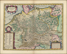
Decorative regional map of Austria, centered on the course of the Donau River and Vienna.
Shows the region from from Enss and sTeyr to Presburg and Altenburg. Pruck, Leoren and Pinkhenfeldt are shown in the south and Borowany, Znaym, Lahamand Nicolspurg in the north. Ornate cartouche with coat of arms.
Matthäus Seutter (1678-1757) was a prominent German mapmaker in the mid-eighteenth century. Initially apprenticed to a brewer, he trained as an engraver under Johann Baptist Homann in Nuremburg before setting up shop in his native Augsburg. In 1727 he was granted the title Imperial Geographer. His most famous work is Atlas Novus Sive Tabulae Geographicae, published in two volumes ca. 1730, although the majority of his maps are based on earlier work by other cartographers like the Homanns, Delisles, and de Fer.
Alternative spellings: Matthias Seutter, Mathaus Seutter, Matthaeus Seutter, Mattheus Seutter
![[ Glatz - 7 Years War ] Des neuen Kriegs Theaters 22. Supplement Plan der Belagerung der Stace und Vestung Glaz...](https://storage.googleapis.com/raremaps/img/small/99034.jpg)
![(Italy and Austria) Carta geografica statistica postale dell’I.R. Monarchia Austriaca e dell’Italia [Statistical postal geographic map of the Imperial Royal Austrian Monarchy and of Italy]](https://storage.googleapis.com/raremaps/img/small/94038.jpg)