|
||

|

|
|

|
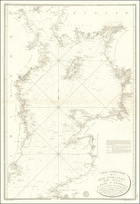
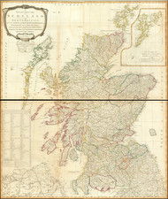
First Map of the British Isles Published North of the Alps
Striking example of this highly soughtafter map of the British Isles, from the 1486 edition of Ptolemy's Geographia.
The map was first issued in the 1482 Ulm edition of Ptolemy’s Geographia, the first atlas printed north of the Alps and the first to contain illustrated woodcut maps. It contains the traditional 27 Ptolemaic maps, of which this example is one, and five additional modern maps: Italy, Spain, France, Scandinavia, and the Holy Land. This map is the most famous and highly-sought after of all fifteenth-century maps of the region.
The present map was prepared for Lienhart Holle based on the cartography of the 2nd-century polymath Claudius Ptolemy. The basis for the present printed map, like most of the maps in the Ulm Ptolemy, was in the mid-15th-century manuscript of Donnus Nicolas Germanus, sometimes called the Wolfegg Codex.
Thile Insulae
To the north of Scotland is Thile Insulae, otherwise known as Thule. Thule is an island referenced in the now-lost narrative "On the Ocean" by Pytheas of Massilia around 330 BC. Pytheas is known to have explored parts of western and northern Europe, likely including England, Ireland, and northern Germany, and he mentioned a land called Thule. The exact location of Thule as described by Pytheas remains uncertain, with various theories suggesting different northern locations. Presently, there is an American Air Force base named Thule located in Qaanaaq, northwest Greenland.
The term Ultima Thule has come to signify the utmost northern point. While some scholars assert they can identify the island Pytheas called Thule, the term is generally accepted as mentioned earlier. In early printed world maps derived from Claudio Ptolemy's Geographia before the first map of the Northern Region appeared in 1482, "Scandia" and "Thule" were used to denote Scandinavia or the most distant part of the known world then. This terminology appears in the 1482 and 1486 "Prima Europe Tabula" (representing Great Britain) and the "Quarta Europe Tabula" (covering Denmark and Germany). In later maps, "Thule" or "Tile" appears variably in the Arctic and the Atlantic Ocean, often identified with Iceland. Interestingly, in some cases.
The Ulm Ptolemy of 1482 and 1486
The Ulm edition of Ptolemy was first published in 1482 by Lienhart Holle. In contrast to the two earlier illustrated editions of Ptolemy's geography - Bologna (1477) and Rome (1478) - the maps in the Ulm edition are woodblock prints, not copperplate engravings. The maps in the Ulm edition follow the manuscript maps of Donnus Nicolaus Germanus, a Benedictine monk from Breslau who produced brilliant presentation copies for Italian elites in the 1460s and 1470s. Specifically, the Ulm was patterned after the manuscript atlas prepared for Pope Paul II. The Ulm Ptolemy was the first book Holle published, but it was also to be one of his last. Holle went bankrupt shortly after the original publication. The work was then taken over by Johann Reger, who issued another edition in 1486.
The differences between the two editions are relatively small. The 1486 maps typically include titles at the top, whereas there were no titles on the 1482 maps. An unpublished study of the individual maps reveals that there are multiple states of most of the maps.
It had long been suggested that the way to differentiate between the 1482 and 1486 editions was the use of lapis lazuli blue in the 1482 edition for the seas, whereas the 1486 used brown. However, the same unpublished study, which evaluated dozens of examples of the two editions, determined that the earliest examples of the 1486 were also issued with the lapis lazuli blue, suggesting that when Johann Reger acquired the woodblocks, he likely also acquired some unused lapis lazuli. In 2021, we offered for sale a complete example of a 1486 entirely in lapis lazuli blue.
Claudius Ptolemy (fl. AD 127-145) was an ancient geographer, astronomer, and mathematician. He is known today through translations and transcriptions of his work, but little is known about his life besides his residence in Alexandria.
Several of his works are still known today, although they have passed through several alterations and languages over the centuries. The Almagest, in thirteen books, discusses astronomy. It is in the Almagest that Ptolemy postulates his geocentric universe. His geometric ideas are contained in the Analemma, and his optical ideas were presented in five books known as the Optica.
His geographic and cartographic work was immensely influential. In the Planisphaerium, Ptolemy discusses the stereographic projection. Perhaps his best-known work is his Geographia, in eight books. However, Ptolemy’s ideas had been absent from western European intellectual history for roughly a thousand years, although Arab scholars interacted with his ideas from the ninth century onward.
In 1295, a Greek monk found a copy of Geographia in Constantinople; the emperor ordered a copy made and the Greek text began to circulate in eastern Europe. In 1393, a Byzantine diplomat brought a copy of the Geographia to Italy, where it was translated into Latin in 1406 and called the Cosmographia. The manuscript maps were first recorded in 1415. These manuscripts, of which there are over eighty extant today, are the descendants of Ptolemy’s work and a now-lost atlas consisting of a world map and 26 regional maps.
When Ptolemy’s work was re-introduced to Western scholarship, it proved radically influential for the understanding and appearance of maps. Ptolemy employs the concept of a graticule, uses latitude and longitude, and orients his maps to the north—concepts we take for granted today. The Geographia’s text is concerned with three main issues with regard to geography: the size and shape of the earth; map projection, i.e. how to represent the world’s curve proportionally on a plane surface; and the corruption of spatial data as it transfers from source to source. The text also contains instructions as to how to map the world on a globe or a plane surface, complete with the only set of geographic coordinates (8000 toponyms, 6400 with coordinates) to survive from the classical world.
![[Fifteen Admiralty Charts of the South Coast of England]](https://storage.googleapis.com/raremaps/img/small/92093.jpg)