


|
||

|

|
|

|
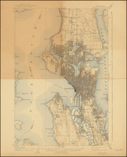
Detailed cadastral map, centered on Port Madsion and the Port Madison Indian Reservation.
Includes dozens of landowner names and contemporary annotations.
The Port Madison Indian Reservation, located near Agate Pass in Washington State, has a history deeply intertwined with the Suquamish people and their interactions with European settlers and the U.S. government. Authorized by the Point Elliott Treaty of January 22, 1855, the reservation was formally established through an executive order on October 21, 1864, as a designated land for the Suquamish Tribe, as well as other Coast Salish peoples such as the Duwamish and Sammamish who later joined the reservation.
Historical records indicate that the first significant contact between the Suquamish and European explorers occurred in 1792 when British Captain George Vancouver explored the Puget Sound. This encounter marked the beginning of increased interactions between the Suquamish and non-Native peoples, escalating with the establishment of British trading posts in the region in the early 19th century.
The establishment of the Washington Territory in 1853 marked a critical period for the indigenous populations as the U.S. government sought to extinguish aboriginal claims to land to facilitate non-Native settlement. This led to the signing of the Point Elliott Treaty in 1855, where the Suquamish, under the leadership of Chief Seattle and others, ceded significant portions of their land to the U.S. government. In return, they retained a designated area for themselves—what is now the Port Madison Indian Reservation—ensuring their rights to fish, harvest shellfish, and maintain their cultural and natural resource rights within their ancestral lands.
Over the years, the reservation has faced challenges, notably the encroachment of non-Tribal ownership due to policies facilitating non-Indigenous land acquisition. Despite these challenges, the Suquamish Tribe has maintained its cultural heritage and sovereignty. Today, the tribe plays a significant role in regional environmental and resource management, acting as a co-manager with the State of Washington for the state's salmon fishery, reflecting their enduring connection to their ancestral lands and waters.
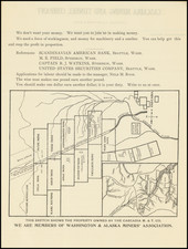
Blueprint & Blue Line maps (Cyanotype Printing)
Blueprint and blue line maps were among the most popular means for the swift printing of maps for which there would be a limited demand. A blueprint or blue line map could be made and/or revised much more quickly than a lithograph, cerograph, or other printing method, and at a much lower cost.
This method of printing was invented in 1842 by John Herschel, a chemist, astronomer, and photographer. A cyanotype process, one starts by drawing on semi-transparent paper, weighted down by a top sheet of paper. The paper would be coated with a photosensitive chemical mixture of potassium ferricyanogen and ferric ammonium citrate. The paper would then be exposed to light, wherein the exposed portions turned blue and the drawn lines, protected from exposure, would remain white.
The cyanotype printing process was an improvement on the expensive and time-consuming method of hand-tracing original documents. The technique was particularly popular with architects; by the 1890s, a blueprint was one-tenth the cost of a hand-traced reproduction. It could also be copied more quickly.
Blueprint and blue line maps began to appear as early as the 1850s and 1860s, but they really began to become the standard for mining and similar limited-purpose maps by the 1880s. The ability to create these maps quickly and at a low cost made them the standard for short-run prints, ideal for mapping mining regions in the West and for similar purposes.
The method still exists today, but in a very limited fashion. In the 1940s, diazo prints (whiteprints or bluelines) became more popular, as they were easier to read and faster to make. The blue lines on a white background of these prints are now what most people call blueprints.
Oliver Phelps (O.P. Anderson) is one of Seattle's first indigenous map publishing companies. Anderson was an amateur photographer and owner of a photographic supplies business in Seattle in the early 1900s. Anderson first worked as a bookkeeper in Seattle in the early 1880s, though by the end of that decade he was doing business as a draughtsman.
The earliest maps bearing Anderson's name appear in about 1885, including the name "Anderson Brothers." Most of these early maps are blue print maps, a style of mapmaking which was becoming more common in the 1880s with publishers looking to produce fast inexpensive maps that were quickly and easily updateable. This form of map was very popular in the west, where the rapid growth of communities, train lines and mining regions were especially robust. The first map jointly issued by Anderson and Whitworth & Thomson was West Seattle five acre tracts . . ., blue print map of a hand drawn plat map from the records of Kings County, circa 1885.
Anderson formed his civil engineering and map publishing business, O.P. Anderson & Co., in the early 1890s, with the business changing its name to the O.P. Anderson Map & Blue Print Co. by the mid 1890s. Beginning around 1900, Anderson began selling photographic supplies as president of Anderson Supply Co., located at 111 Cherry Street in Seattle.
Around 1913, Anderson's son, Maurice P. Anderson, took over as president of the company, and Anderson acted as secretary-manager, a position he continued to hold until around 1940, probably until his death. Anderson Supply Co. continued to do business, with Maurice Anderson as president, until the late 1950s.
![Pacific Coast Highways Canada to Mexico [Texaco Tour Maps Routes and Mileages Canada to Mexico]](https://storage.googleapis.com/raremaps/img/small/91594.jpg)
![[ Jefferson County - Olympic National Forest ] Quinalt Indian Reservation Township No. 24 North, Range No. 12 West, Willamette Meridian Washington](https://storage.googleapis.com/raremaps/img/small/101909.jpg)