|
||

|

|
|

|
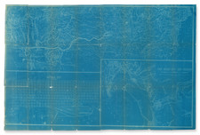
A Short Lived Early San Diego Railroad Line
Detailed map of a portion of the route of the San Diego, Old Town & Pacific Beach Railroad, extending from Old Town to Middletown, first drawn in 1888 and here copied in 1914.
Running from the center of today's history Old Town toward Little Italy, this short lived commuter line shows a bygone era of San Diego history, with a fair amount of the area shown now part of the Highway 5 and the current Santa Fe Railroad route.
This map was likely used for litigation, circa 1914.
San Diego, Old Town & Pacific Beach Railroad
The story of the San Diego, Old Town & Pacific Beach Railroad begins with the San Diego & Old Town Railway, organized by George Neal and James McCoy, which was first granted a franchise in August 1886, one of the country's early experiments with electric traction. By November 1887, the railway, initially using steam "dummies", commenced operations. However, the venture into electric motors, despite being pioneering, was short-lived due to technical challenges, leading to a reversion to steam power.
The following year, the San Diego and Pacific Beach Railway Company was created to serve the newly created community of Pacific Beach. This venture received a franchise from the San Diego city council for a right of way around Mission Bay, connecting Old Town with Pacific Beach. The route followed Grand Avenue, deliberately wider than other streets to accommodate the railroad. Construction began at Morena in December 1887, with a temporary interchange connecting to the California Southern Railroad, a crucial link to downtown San Diego.
In April 1888, the San Diego, Old Town & Pacific Beach Railway emerged from the consolidation of the San Diego & Pacific Beach Railway and the San Diego & Old Town Railway. This new entity faced immediate challenges, including floods in 1889 and 1893 that damaged the railway and tragically claimed the life of Master Mechanic W. O. Wilson. In 1894, the railway was extended to La Jolla, under the leadership of J. Malcolm Forbes in 1894.
The railway, supporting local industries, switched from coal to oil burning in 1901. However, the rise of automobile traffic and improved road systems gradually diminished the railway's relevance. By 1906, the Los Angeles & San Diego Beach Railway was formed, absorbing the existing lines. Despite this consolidation, the railway could not withstand the changing transportation landscape and was eventually abandoned in 1919.
Rarity
The map is unrecorded.
This is the first time we have seen this map.
Blueprint & Blue Line maps (Cyanotype Printing)
Blueprint and blue line maps were among the most popular means for the swift printing of maps for which there would be a limited demand. A blueprint or blue line map could be made and/or revised much more quickly than a lithograph, cerograph, or other printing method, and at a much lower cost.
This method of printing was invented in 1842 by John Herschel, a chemist, astronomer, and photographer. A cyanotype process, one starts by drawing on semi-transparent paper, weighted down by a top sheet of paper. The paper would be coated with a photosensitive chemical mixture of potassium ferricyanogen and ferric ammonium citrate. The paper would then be exposed to light, wherein the exposed portions turned blue and the drawn lines, protected from exposure, would remain white.
The cyanotype printing process was an improvement on the expensive and time-consuming method of hand-tracing original documents. The technique was particularly popular with architects; by the 1890s, a blueprint was one-tenth the cost of a hand-traced reproduction. It could also be copied more quickly.
Blueprint and blue line maps began to appear as early as the 1850s and 1860s, but they really began to become the standard for mining and similar limited-purpose maps by the 1880s. The ability to create these maps quickly and at a low cost made them the standard for short-run prints, ideal for mapping mining regions in the West and for similar purposes.
The method still exists today, but in a very limited fashion. In the 1940s, diazo prints (whiteprints or bluelines) became more popular, as they were easier to read and faster to make. The blue lines on a white background of these prints are now what most people call blueprints.
![(San Diego Photograph) 225. San Diego Mission. Oldest in the State. Established 1769 [Original boudoir card format albumen photograph of San Diego Mission and St. Anthony's Indian School Girl's Dormitory]](https://storage.googleapis.com/raremaps/img/small/92622.jpg)
![[San Diego & Vicinity] Home Federal Country](https://storage.googleapis.com/raremaps/img/small/71369.jpg)
![Air Log Western Air Express [Los Angeles-San Diego, Las Vegas-Los Angeles, Milford-Vegas, Salt Lake City-Milford]](https://storage.googleapis.com/raremaps/img/small/85953.jpg)