
The item illustrated and described below is sold, but we
have another example in stock. To view the example which
is currently being offered for sale, click the
"View Details" button below.


|
||

|

|
|

|
Stock# 100059
Description
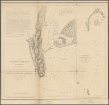
Original Pastel Drawing on The First American Map of the Bay of San Diego
Created in the early 1990s, this is an example of the original artwork of Frank Parsons, who has drawn the iconic Star of India on a modern copy of the US Coast Survey's first mapping of San Diego Bay.
The plan of the harbor covers the area from Point Loma and La Playa in the west to Shelter Island, with extensive soundings taken. Point Loma, Ballast Point, La Playa, an Observatory, ship wreck and various buoys are noted. Larger inset diagram shows the entire bay. Extensive sailing notes in the upper left corner. One of the earliest obtainable maps of San Diego.
![Southeastern Portion of California [San Diego, San Bernardino and Inyo Counties]](https://storage.googleapis.com/raremaps/img/small/83750.jpg)
![[La Jolla Farms / Scripps Institute of Oceanography] Referee's Partition Map of Pueblo Lots 1312 and 1313 of the City of San Diego, California, as made in accordance with an order from the Superior Court of San Diego County California, made in the action entitled Winnifred Murtha et al vs. Louis D. Radgesky, et al. . . .](https://storage.googleapis.com/raremaps/img/small/77020.jpg)
![(San Diego - Pacific Beach) R. O. W. Map of the Pacific Beach Railroad [Old Town, False Bay, Grand Ave. to Broulett's or Brouillette's Addition]](https://storage.googleapis.com/raremaps/img/small/97271.jpg)
![Partition of Rancho Mission of San Diego San Diego, California -- Made under Decree of Superior Court dated January 7th, 1885, By Chas. J. Fox, C.E, O.H. Borden, M.C. Woodson ] Referees. Filed January 14th 1886. J.M. Dodge, Clerk.](https://storage.googleapis.com/raremaps/img/small/101388.jpg)