|
||

|

|
|

|
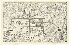
19th-Century Map of Pacific Beach: Railroad Access to the Beach in 1887
San Diego and Pacific Beach Railway from Old Town to the Foot of Grand Ave.
One of the earliest maps to show any part of the Pacific Beach subdivision of San Diego. P.B., as bustling Pacific Beach is colloquially known today, was founded in 1887 on erstwhile farmland known for its lemon orchards. The place grew in fits and starts through the first few decades of the 20th century before experiencing explosive growth after WWII. This early manuscript map, which dates from circa 1887, is notable for showing most of the then proposed route of the Pacific Beach Railway, between Old Town and Pacific Beach. The street names and tentative layout of the as-yet unlabeled railroad depot near the foot of Grand Ave., suggest the map was most likely made in 1887, the very year a syndicate of wealthy investors incorporated both the Pacific Beach Company and the San Diego and Pacific Beach Railroad Company. The map was made for a right-of-way case concerning access to planned railroad depot grounds near the beach (San Diego & Pacific Beach Railway Co. vs. J. F. Brouillette).
The San Diego, Old Town and Pacific Beach Railway
The railroad, which would become the San Diego, Old Town and Pacific Beach Railroad (later extended to La Jolla), ran from the site of the current Santa Fe depot in downtown San Diego to a point near the foot of Grand Avenue in Pacific Beach. Our map shows part of the route in red ink beginning at Old Town on Fitch Street near Washington Square, north along the California Southern Railroad, then hugging the east side of False Bay (Mission Bay), before wrapping west into Pacific Beach proper along the northern boundary of Pueblo Lot No. 1797 (once the site of a racetrack); then west on Grand Ave. making a beeline for the ocean which is interrupted by a sharp turn south at 2nd Street (present day Bayard St.) curving across land currently taken up by a Ralphs supermarket, and finally onto 1st Street (present Mission Blvd.) On Wheeler's original 1887 subdivision map of Pacific Beach this railroad stopping point is labeled the Depot Grounds, but the land is here an unnamed block adjacent to Broulett's or Brouillette's Addition. In 1894 the railroad inaugurated service to La Jolla along present day Mission Boulevard, La Jolla Hermosa Drive, Electric Avenue and Cuvier Street to a station on Prospect Street. The Pacific Beach and La Jolla Railroad became the Los Angeles & San Diego Beach Railroad in 1906 - although the tracks never advanced beyond La Jolla.
Brouillette's Addition
Brouillette's Addition, located south of Grand Ave, just north of the present Catamaran Hotel, between Bayard and Cass Streets, would be subsumed in 1904-05 into F. T. Scripps's high-class Braemar subdivision. Maps from 1905 clearly identify the land as part of Braemar. It is interesting to note that Brouillette's property was never purchased by the Pacific Beach Company and often appeared as a blank space on the early Pacific Beach maps. Our map stems from the company's issue with Brouillette over access to the planned depot grounds. Though the map has a handwritten note referencing "San Diego & Pacific Beach Railway Co. vs. J. F. Brouillette" we have also seen his name transcribed as John B. Brouillette. The last mention of Brouillette’s Addition in the lot books was in 1907, by which time the land was owned by F. T. Scripps.
Railroad Access to the Beach
The present somewhat spartan map is an elegant snapshot of early rail access to one of San Diego's finest beaches, and provides evidence of how the original railroad connection to Pacific Beach determined present-day automobile access to the neighborhood. One artifact from the railroad route continues to impact car driving in P.B. to this day: motorists driving east on Grand Ave are confronted with a perennial traffic bottleneck at the Balboa Ave. fork at Lamont St. (11th Street on this map). Last minute lane changes made by drivers attempting to avoid the backup of cars bearing left to Balboa have resulting in innumerable car crashes over the years.
As noted by John Webster:
In October 1887 H. K. Wheeler, City Engineer, drew up a subdivision map in which the entire area from the ocean to Rose Creek and from the southern tips of Crown Point and Mission Beach to the Mt. Soledad foothills was divided into rectangular blocks by a grid of north-south streets and east-west avenues. The streets and avenues were all 80 feet wide except for Broadway (now Ingraham Street), the main north-south street, which was 100 feet wide and Grand Avenue, the main east-west avenue, which was 125 feet wide. Each block was 270 feet north-to-south and 500 feet east-to-west and was further subdivided into 40 lots; 20 lots 25 feet wide and 125 feet deep lining the avenue on either side of the block with a 20-foot-wide alley behind each lot connecting the streets at each end. The streets were numbered, beginning with First Street near the beach to Seventeenth Street near Rose Creek, plus Broadway, which was between Eighth and Ninth. North of Grand Avenue, the avenues were all named for states, with the exception of College (now Garnet) Avenue. South of Grand the avenues were named for officials or associates of the Pacific Beach Company; Thomas, Reed, Gassen, Hubbell, Hensley, Platt, Metcalf, Hale, Collins and Poiser... Grand Avenue was extraordinarily wide because it was meant to accommodate the right-of-way of a steam railway from San Diego to a depot at the beach near the foot of Grand, which itself was allocated several blocks of land. Grand Avenue (and the railroad right-of-way) followed the same east-west alignment as the other avenues between the beach and Eleventh Street but east of there it turned and sliced through several of the regular rectangular blocks that circle around north of the racetrack which had been laid out east of Rose Creek and north of the bay. Blocks on the western and southern edges of the subdivision were of irregular sizes and shapes to fit the shoreline of the ocean and bay - Webster, Originally Pacific Beach, pages 4-5.
Pacific Beach and Its Street Names
Defunct Street names shown on the map include Broadway (present day Ingraham) and all north-south streets shown, which are here numbered streets begining with 1st Street (present Mission Blvd.); 2nd St. (Bayard); 3rd. Street (Cass St.) and so on through 14th Street (present Olney St) and 15th Street (a no longer extant street between Olney and Quincy Streets). The numbered street names and Broadway would be changed in an 1890s revision of the Pacific Beach subdivision map, likely because these duplicated similarly named streets in downtown San Diego.
Zena Locker has summarized the beginnings of P.B. in a classic article on the history of street names in Pacific Beach:
Like many other areas of the city, Pacific Beach was conceived and born during that period of local insanity known as the Boom of the 'Eighties. Two transcontinental railroads to Southern California having been finished, land developers and speculators moved in. The first subdivision map of Pacific Beach was platted and the land put on the market in October, 1887, by the Pacific Beach Company. Promoters of the new subdivision were D. C. Reed, A. G. Gassen, Charles W. Pauley, R. A. Thomas and O. S. Hubbell, who "cleared away the grainfields, pitched a tent, mapped out the lots, hired an auctioneer and started to work." Curiously enough, the original map was not filed with the County Recorder until January 2, 1892, a fact which would have a later bearing on some street names.
The 1887 map included more than two square miles of territory, about half of it subdivided into city blocks and lots with streets designated, the other half divided into small acreages with few streets. The tract ran approximately two and a half miles east from the ocean, and a scant mile north from the northernmost curve of False Bay (now Mission Bay) to present-day Loring Street. An ambitious project this was for the entrepreneurs Reed, Gassen, et al, considering the fact that new subdivisions were sprouting like mushrooms all over the city and county -- indeed, over all Southern California -- and were competing for the speculator's dollar.
Every new real estate venture had to have an "attraction" with which to lure buyers. Pacific Beach was amply blessed with attractions -- plural. First, the Creator Himself had provided the Pacific Ocean, the shores of which, on the subdividers' promotional map, were modestly labeled, "The Finest Beach in the World." Beckoning to those more interested in horseflesh than human flesh (and anyway, how much human flesh could be seen on the beach in 1887?) there was the Race Track, with stables and grandstand. This was situated near the northeastern curve of False Bay. . . . To attract the literati, there was the projected "San Diego College of Letters," of which Harr Wagner and Rose Hartwick Thorpe were the imported superstars. Last but most important, there was a railroad connecting these attractions with each other and with the rest of San Diego, the San Diego, Old Town and Pacific Beach Railroad, which some time later was extended to La Jolla. - Whatever Happened to Izard Street? Pacific Beach and Its Street Names. The Journal of San Diego History, Spring 1976, Volume 26, Number 2.
A wonderful and unique San Diego map, which contributes to our understanding of the fabric of urban and infrastructural development in late 19th-century Southern California, the results of which live on in today's automobile-centric transportation routes.
Rarity
Manuscript maps of San Diego dating from 1880s are rare in the market. Unique subdivision-related maps concerning railroad rights-of-way disputes and coastal access are especially prized.
![(San Diego Water Management) Map of the Dam and Reservoir Site on the Sweetwater River, San Diego County, California belonging to San Diego Land & Town Co. March 1887 [Jamacha Rancho]](https://storage.googleapis.com/raremaps/img/small/97272.jpg)