


|
||

|

|
|

|
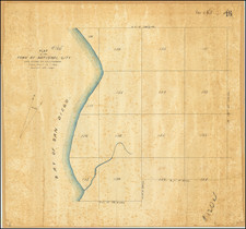
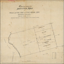
Early Map of The Future La Jolla Farms -- Likely The Oldest Surviving Map of the Future LJ Farms
Early map of the area which is is now La Jolla Farms, Salk Institute, Torrey Pines Glider Port, Black's Beach, Estancia Hotel, Mushroom Beach House and Sumner Canyon
The map resulted from partition litigation to divide lands owned by Louis Radgesky, following his death of San Francisco. The San Diego Union records the results of the lawsuit and completion of the partition map on December 30, 1908.
The land in question shows a number of owners, but would shortly thereafter be acquired by one of the owners Frederick Tudor Scripps, who maintained the property as a private hunting ground. During his lifetime, one of his guests on the property was William Black.
William Black and his wife Ruth Faulkner Black had moved to the area in 1937, but maintained a primary residence in New Mexico. It seems that a major factor delaying the Blacks from permanently returning to La Jolla was their desire to acquire a large tract of ocean-side land known as the Scripps Biological Cliffs. William Black had first visited and fell in love with the property during the 1920s when he was a frequent hunting guest of Fred Scripps, the parcel’s owner. The property at that time was completely undeveloped and Scripps used it primarily as his private hunting reserve. The parcel came on the market once after Scripps’ death, but Black failed in an attempt to purchase it at that time. Black’s patience and persistence eventually paid off: in 1947 the land came on the market once again and he was able to secure the property, which consisted of 248 acres of oceanfront real estate that encompassed the bulk of San Diego Pueblo Lots 1312 and 1313.
The Blacks developed a horse training facility and called it La Jolla Farms. In 1949, they began to convey bluff-top lots to friends desirous of home sites overlooking the Pacific. In time they selected their own parcel and commissioned Santa Fe architect William Lumpkins to design a house in the pueblo revival style. The remaining land would be divided into 92 parcels, which is today's La Jolla Farms.
A portion of the land (72.12 acres) was used by Camp Callan during World War II, pursuant to a lease with FT Scripps Inc. In 1966, the Blacks sold 132 acres of the original 248 acres to UC San Diego.
The land owners named on the map include:
- Louis D. Radgesky
- Winnifred Murtha
- T.A. Nerney
- Charles C. Carr
- George S. Carr
- Madora Jones and Leila Wellborn
- Jacob Bertz
- San Diego Realty Company
- F.T. Scripps
Rarity
The City of San Diego holds a photostatic copy of a similar map. We suspect that the San Diego County Recorder also holds an example of the map.
![[Historical Map of Julian, California]](https://storage.googleapis.com/raremaps/img/small/94157.jpg)