This item has been sold, but you can enter your email address to be notified if another example becomes available.


|
||

|

|
|

|
Stock# 0703
Description
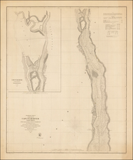
Marvelous example of Tanner's map of South Carolina, with large inset map of Charleston, from the last edition of Tanner's Universal Atlas. This example of the map was first issued in 1841. It is hand colored by counties, and shows towns, roads with distances, steam and stage routes, railroads, canals, and a host of other details. The Charleston key includes about 45 place names, streets and substantial detail. A lightly toned example, with a bit of soiling, but wide margins and overall a nice example of Tanner's map, which rarely appears on the market.