


|
||

|

|
|

|
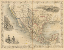
Brue's map of Mexico, Texas and Upper California is one of the few atlas maps to name the Republic of Texas in the Title. Marvelous detail throughout Texas, New Mexico, the Rocky Mountains, California and the Plains. California's cartogarphy is pre- Fremont, although some of the myths such as the second Salt Lake and the Rivers connecting them to the Ocean are gone. Nice detail along the West Coast, including the Spanish Missions and along the Colorado River. Now for the curious part. The colorist has ignored the dotted lines & colored the map as if it were issued in the late 1850s. This is a curious error, as Brue updated this map frequently & issued of pre- and post-Gadsden updates. Unquestionably pre-1845, although curiously colored!
Andre Hubert Brué was a French geographer and cartographer. Born in Paris, he served in the French Navy, joining the Baudin expedition to the Pacific (1800-1804). After his sea service, Brué applied his navigation and charting skills to creating finely-crafted maps, which were renowned for their crisp engraving and accuracy. He drew directly on the copper of the plate, creating what he called encyprotypes. He is best known for the Atlas universal de géographie physique, politique, ancienne et moderne.

![[Shows Republic of Texas] United States and Texas](https://storage.googleapis.com/raremaps/img/small/101139.jpg)