|
||

|

|
|

|
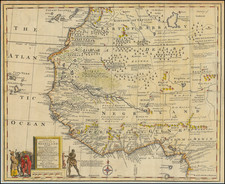
Northwestern sheet from Du Val's rare 4 sheet map of Africa, one of the first attempts at a more scientific mapping of the continent. The cartography is a bit wider from east to west than usual. Highly detailed in the interior, showing mountains, rivers, lakes, tribes, towns, islands and other features. Text on left shows various features of each of the major regions. Trimmed to the neatline of the title section at the bottom, but nto affectign the map image. The four sheet map is now selling for over $5,000.00 on the rare occasions where it can be located.
Pierre Duval (1618-1683) was a French geographer, cartographer, and publisher who worked in Abbeville and Paris during the seventeenth century. He was born in the former city, in northeast France, before moving to Paris. Duval was the nephew of the famous cartographer Nicolas Sanson, from whom he learned the mapmaker's art and skills. Both men worked at the royal court, having followed the royal request for artists to relocate to Paris. In addition to numerous maps and atlases, Du Val's opus also includes geography texts. He held the title of geographe ordinaire du roi from 1650 and died in 1683, when his wife and daughters took over his business.
![X. b [Congo]](https://storage.googleapis.com/raremaps/img/small/93299.jpg)
![VIII. b [West Africa]](https://storage.googleapis.com/raremaps/img/small/93298.jpg)
![[ Atlas of Africa ] L'Afrique en Plusieurs Cartes Nouvelles, et Exactes; &. En Divers Traictes de Geographie, et D'Histoire.](https://storage.googleapis.com/raremaps/img/small/68986.jpg)