|
||

|

|
|

|
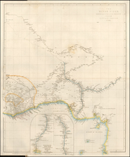
This 1702 map by German cartographer Johann Ulrich Müller presents a detailed depiction of the region of present-day Congo and its surrounding areas in Central Africa. The map features various place names, geographical terms, and descriptors that accurately reflect the locations, rivers, and territories of the region during the early 18th century.
The text describes the divisions of the coast of Congo into several regions or kingdoms:
-
Congo itself, which is further divided into: a. Bamba, with Bamba b. Songo, with Songo c. Sundo d. Bata e. Bemba, with S. Salvador (likely referring to the Kingdom of Kongo and its capital city São Salvador, present-day M'banza-Kongo)
-
The Kingdom of Loango, which is divided into: a. Lovangini, with Loango (likely referring to the capital of the Kingdom of Loango) b. Lovango c. Gylongo d. Pyri
-
Angola


![[Azores and Cape Verde Islands to West Africa & Spain] Barbariae et Guineae Maritimi a Freto Gibraltar ad Fluvium Gambiae cum Insulis Salsi Flandricis et Canaricis](https://storage.googleapis.com/raremaps/img/small/74954.jpg)