This item has been sold, but you can enter your email address to be notified if another example becomes available.


|
||

|

|
|

|
Stock# 0049
Description
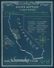
Extremely scarce early map of California, one of the earliest to focus on the region between San Francisco and San Diego and include inland topographic detail. The southern extremities include details at the confluence of the Colorado and Gila and an early reference to Pala east of the Mission San Luis Rey in NE San Diego County. The missions in S. Diego, S. Luis Rey, S. Bernardino, S. Gabriel, S. Buenaventura, S. Barbara, S. Ynes, La Purissima and S. Luis Obispo are shown, as are Pueblo, S Pedro, Moneterey Bay, San Francico, the Channel Islands and Catalina. A massive Tule Lake and Snowy Mountains are shown, along with the Rocky Mountains (Sierras). The first printed map exclusively devoted to a large region of the State of California.