|
||

|

|
|

|
Joint Highway District No. 12
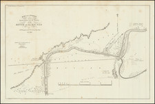
Interesting highway planning map, illustrating a proposed section of Highway between Knights Landing on the Sacramento River in Yolok County and the Town of Tudor in Yolo County, with a larger overview map at the left illustrating the wider area of the proposed highway section.
The map is a detailed "Plan and Profile of the Woodland-Yuba City Cutoff" between Knights Landing Ridge in Yolo County and the Gaden Highway one half mile west of Tudor in Sutter County. It represents a segment of work overseen by the Joint Highway District No. 12 of the State of California.
The detailed design includes a key map indicating the general layout of the highway district, showing key towns and the intricate network of proposed highways. A vignette of the California State Capitol surrounded by grape leaves is prominently featured, suggesting the state's involvement and pride in infrastructure development.
This specific section, labeled as "Layout No. 2," comprises sections 1, 3A, and a portion of 5, with the total length of the layout annotated. The map also indicates completed sections of the highway with solid lines, while dotted lines show proposed extensions. The map was officially adopted by the Board of Directors and approved by an engineer named Edward J. Geldeen, along with J.A. Madden, Assistant Engineer.
From a historical perspective, the map underscores the growth and development of transportation infrastructure in California during the late 19th and early 20th centuries, a period when road building was essential to support economic expansion and the mobility of goods and people. This would have facilitated the development of the regions shown, impacting local economies, and connecting communities.
Rarity
The map is a unique survival.
We locate no other examples.

![[ Pacific Coast Pictorial Road Maps ] Scenic Touring Scout](https://storage.googleapis.com/raremaps/img/small/101745.jpg)