The item illustrated and described below is sold, but we
have another example in stock. To view the example which
is currently being offered for sale, click the
"View Details" button below.
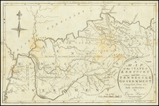
1796 Jedidiah Morse
$ 750.00


|
||

|

|
|

|
Stock# m0355
Description
Highly desireable early map of the two states, showing military reservation boundaries, Indian boundaries, early towns, roads, rivers, mountains, lakes, Indian Villages, counties and a host of other details. Issued in Morse's American Univeral Geography. Wheat & Brun 645. One of the earliest obtainable maps of the region and one of the earliest published in America.