Striking Folio World Atlas with Previously Unrecorded Maps—the Only Known Folio Atlas by Mondhare
Fine atlas with maps by renowned seventeenth-century French mapmaker Hubert Jaillot. The maps of the continents and the world have been revised by Louis Joseph Mondhare and this is the only folio-sized atlas the Paris map publisher is known to have made.
The atlas contains a title page, a table of contents, forty maps, and thirteen Tables Geographiques. Together, the maps show the entire world as it was known in ca. 1785, when the world and continent maps were updated, and in ca. 1696, when Jaillot (1632-1712) finished the other maps included in the atlas. Additionally, there are several maps by J. B. Nolin (ca. 1657-1708). The decorative title page shows a neoclassical façade with statues and battle motifs representing the might of France. The page is an atlas title page from Jaillot, dated 1692(?), and dedicated to the Dauphin of France. The Dauphin at this time was Louis of France (1661-1711), Le Grand Dauphin and son of Louis XIV, the Sun King (1638-1715). The Dauphin’s son, also Louis, was born in 1682 (d. 1712) and known as Le Petit Dauphin. Both Dauphins predeceased Louis XIV, leaving him to pass his crown to his five-year old great-grandson, another Louis (1710-1774). At the time this atlas was revised in ca. 1785, Louis XV’s long reign had ended, with his son, Louis XIV (1754-1793), succeeding him.
Behind the title page is a beautiful, original color (?) table of contents page. The label references Nicolas Sanson, France’s most prominent mapmaker of the seventeenth century. Jaillot was in partnership with Sanson’s sons and was known for reworking Sanson maps, so this title page is in line with the re-issue of the Jaillot/Sanson maps in the volume. The vignettes on the page include mighty Atlas, savants puzzling over a globe in a grand library, and gods overlooking the entire scene.
As per usual in atlases, the world map and those of the continents are the first in the series of maps to follow. These six maps have been updated by Mondhare, revised with the latest in exploration and geographic innovation to ca. 1785. Europe, for example, has had the tracks of explorers added, including those of Cook and Gore, a reference to Cook’s third voyage to the Pacific (1776-1780). The Asia map also includes Cook and Gore’s routes, as well as the circuit of the Acapulco-Manila treasure galleons. Africa and South America also have many explorer tracks added. The world map and map of North America will be discussed in more detail below; these two maps are previously unrecorded and new to map scholarship.
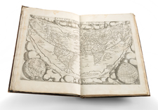
World map
The double hemisphere world map is based on a Sanson map, as explained in the title at the top, but it has been revised by Mndhare, as the cartouche in the lower center reveals. That cartouche is very elaborate, with mermaids and floral arrangements surrounding a title cartouche at bottom, and the coat of arms of XXX at the top.
The cartouche embellishments are taken from Sanson, but the astronomical diagrams in the four corners are newly added in this map. They each represent the theory of the organization of the solar system. One is the geocentric idea from Ptolemy, the heliocentric hypothesis of Copernicus, and Tycho Brahe multi-orbit theory in which all planets orbit the Sun, and the Sun orbits Earth. The final corner shows a composite view.
An important addition is the M. de l’Ouest, a reference to the chimerical Sea of the West. This sea had first appeared on charts published by Johann Baptiste Nolin in ca. 1700 but had quickly disappeared thereafter. Although the great French geographer Guillaume De L'Isle never published a map showing the sea, he had postulated that it could exist, and that it might connect to a Northwest Passage through New France, not through English territory farther north. Nolin had plagiarized the idea from Guillaume, as the latter testified when suing the former for plagiarism. He said, the Sea of the West "was one of my discoveries. But since it is not always appropriate to publish what one knows or what one thinks one knows, I have not had this sea engraved on the works that I made public, not wanting foreigners to profit from this discovery" (as quoted in Pedley, 109).
The Sea of the West began to appear again in the 1752, when Joseph-Nicolas Delisle, Guillaume's brother, and Buache, his son-in-law, published a map showing the Russian discoveries in the far north Pacific. Buache had reviewed his father-in-law's papers and read of the Sea of the West. He and his uncle included the sea on their map, which was also presented to the Acàdemie, and it spread to other maps—including this one—thereafter.
The routes of many explorers are added to this world map, as they are to the continents. These include Magellan, the first to circumnavigate the world; Mendaña, who searched for the southern continent; Tasman, the first European to encounter New Zealand; Le Maire, who opened a new route to the Pacific via Cape Horn; Halley, the astronomer who sailed the South Atlantic studying magnetic variation; and Bougainville, the French navigator who was one of the first Europeans to visit Tahiti.
The most important navigator marked on this world map is Captain James Cook. His three Pacific voyages delineated the vast ocean which covers one-third of the earth. He brought back news of previously unknown (to Europeans) islands and cultures, paving the way for imperial expansion to Australia, New Zealand, and the island nations. When this map was published, in ca. 1785, Cook was at the height of his popularity, due in large part to his sensationalized death in Hawaii in 1780. The tracks of his associate, Furneaux, who commanded a ship on Cook’s third voyage, is also included on this map. Interestingly, while certain details have been added, Mondhare has not updated other geographic features. For example, New Zealand and New Guinea are both shown in rudimentary shapes, even though the Pacific voyages marked on this map had charted them more accurately. It is likely the plates used for printing could not be altered adequately to show these changes.
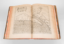
North America map
The North America map is also unrecorded. It is based on a Jaillot map, but Jaillot name has been removed from the scale cartouche in the lower left. There is considerably more detail to the far north, although the geography is still tentative. Boston has been added to the map, and “Louisiane” is used in the south rather than “Floride.” On earlier states of the Jaillot North America, California was shown as an island, but here it is an peninsula connected to the Sea of the West to the north.
It shows the Mer ou Baye de l’Ouest in even greater detail. There are two entrances to the bay, one discovered by Juan de Fuca and the other by Martin de Aguilar. Juan de la Fuca, the Castilianized name of Greek navigator Ioánnis Fokás (Phokás). Little archival evidence survives of Fuca’s career, but a chance meeting with an English financier, Michael Lok, in Venice in 1596 gave birth to rumors of Fuca’s voyages in the Pacific. Fuca reported that he had been sent north from New Spain twice in 1592 in search of the Strait of Anian. Interestingly, this map includes a date of 1696(?) for de Fuca’s discovery. The Spanish Crown failed to reward Fuca’s discovery of an opening in the coast at roughly 47° N latitude and Fuca left the Spanish service embittered. His story lived on in Lok’s letters and eventually was published in Samuel Purchas’ travel collection of 1625. On many eighteenth-century maps, including this one, Fuca’s Strait is linked with a River or Sea of the West. In 1787, the present-day Juan de Fuca Strait was named by the wife of naval explorer Charles William Barkley, making permanent a label that had previously just been hopeful conjecture.
Martin Aguilar was a Spanish captain who sailed with Sebastian Vizcaino on a reconnaissance expedition up the California coast in 1602-3. Aguilar, commanding the Tres Reyes, was blown off course, to the north. When the seas calmed, Aguilar reported that he had found the mouth of a large river. Eighteenth-century geographers conjectured that the river was the entrance to the Sea of the West, as it is positioned on this map.
Census of maps included in the atlas
- Mappe-Monde Geo-Hydrographique, ou Description Generale du Globe Terrestre et Aquatique en Deux Plans-Hemispheres ; ... Par le sieur Sanson, Geographe ordinaire du roy. 1785. Revue Corrigée et Augmentée des Nouvelles Decouvertes et des Voyages des Plus Celebres Navigateurs dans la Mer du Sud et au Nord de l'Asie. 1785. A Paris chez Mondhare rue St. Jean de Beauvais
- L’Europe divisée… chez Mondhare, 1785
- L’Asie divisée… , 1785
- L’Afrique divisée… et présentement chez Mondhare rue St. Jean de Beauvais, 1785
- Amérique Septentrionale divisée…, 1785
- Amérique méridionale…, 1785
- Les Isles Britanniques... H. jaillot, 1692
- Le Royaume d’Angleterre... H. Jaillot, 1693
- Le Royaume d’Ecosse... H. Jaillot, 1693
- Le Royaume d’Irlande... H. Jaillot, 1693
- Carte de la Manche... H. Jaillot, 1692
- La Scandinavie... H. Jaillot, 1696
- Le Royaume de Danemark ou sont les Isles de Seelande... H. Jaillot, 1692
- La Russie Blanche ou Moscovie... H. Jaillot, 1692
- Le Royaume de France... H. Jaillot, 1692
- La Bretagne... le Sr. Sanson, 1696
- Le Gouvernement General de Picardie... H. Jaillot, 1692
- Le Gouvernement General de l’Isle de France ... ... H. Jaillot, 1692
- Gouvernement General de Paris... H. Jaillot, 1692
- Gouvernement General de Champagne... H. Jaillot, 1692
- Le Gouvernement d’Orleans... H. Jaillot, 1693
- Le Gouvernement General du Dauphiné... ... H. Jaillot, 1692
- Gouvernement General de Provence... H. Jaillot, 1692
- Le Duché et Gouvernement de Normandie... I. B. Nolin, 1742
- Le Comté d’Artois... H. Jaillot, 1696
- La Franche-Comté... H. Jaillot, 1692
- La Lorraine... H. Jaillot, 1692
- L’Alsace... H. Jaillot, 1692
- Carte particuliere des Postes de France... H. Jaillot, 1693
- L’Espagne... H. Jaillot, 1692
- Principauté de Catalogne… H. Jaillot, 1696
- L’Italie Divisée... H. Jaillot, 1692
- Les Estats de Savoye et de Piemont... I.B. Nolin, 1691
- Partie du Duché de Milan... H. Jaillot, 1692
- Les Monts Pyrenées ... H. Jaillot, 1691
- Les Montagnes des Alpes... H. Jaillot, 1692
- Le Royaume de Naples... I. B. Nolin
- La Sicile... H. Jaillot, 1692
- Le Golfe de Venise... H. Jaillot, 1693
- La Mer Méditerranée... H. Jaillot, 1696
Rationale and rarity
This is the only known folio atlas which Mondhare issued, which begs the question, why make this atlas in the first place? The unfinished title page and use of older maps suggests it is an experiment. It is likely that Mondhare was responding to calls for innovation from Pierre Jean, his son-in-law with whom he entered into a partnership in 1784. He may also have been trying to gain royal favor by preparing a grand atlas that could be dedicated to a member of the royal family, perhaps the young Dauphin who had been born in 1781. In that case, this could be a prototype. Also plausible is the idea that Mondhare was preparing this atlas at the request of a client, although the use of previously unrecorded world and North America maps suggests it was the first stage in a larger project. Whatever the reason, the atlas contains precious maps that are previously unrecorded—it is an extraordinary cartographic object. It would make a unique contribution to any atlas, world map, North America map, or French map collection.
Alexis-Hubert Jaillot (ca. 1632-1712) was one of the most important French cartographers of the seventeenth century. Jaillot traveled to Paris with his brother, Simon, in 1657, hoping to take advantage of Louis XIV's call to the artists and scientists of France to settle and work in Paris. Originally a sculptor, he married the daughter of Nicholas Berey, Jeanne Berey, in 1664, and went into partnership with Nicholas Sanson's sons. Beginning in 1669, he re-engraved and often enlarged many of Sanson's maps, filling in the gap left by the destruction of the Blaeu's printing establishment in 1672.
![[ Atlas of Africa ] L'Afrique en Plusieurs Cartes Nouvelles, et Exactes; &. En Divers Traictes de Geographie, et D'Histoire.](https://storage.googleapis.com/raremaps/img/small/68986.jpg)
![(Atlas of the Aegean -- Extra Illustrated!) L'Egeo redivivo o' sia chorographia dell' arcipelago, e dello stato primiero, & attuale di quell' isole. . . [The Aegean revived, or the chorography of the archipelago, and of the original and current state of those islands. . .]](https://storage.googleapis.com/raremaps/img/small/93229.jpg)