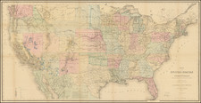
Mammoth map of the United States, issued in 6 separate sheets, but the General Land Office.
The mp represents the best detail available from the General Land Office to date. A similar map was also published in 1874, both of which are very rare. This map, "published under the direction of the Hon. S.S. Burdett, Commissioner," in 1875, is one of the very few general maps produced by the GLO in this period. All maps produced under Burdett were drawn by Charles Roeser, who served as GLO mapmaker from about 1871 to 1882, after which he left to join the U. S. Postal Service where he produced Post Route Maps until the early 1890s. By comparison, Roeser's Burdett maps are quite rare with no recorded sales for the atlas and only a few recorded sales of its maps over the past several decades.
The General Land Office (GLO) refers to the independent agency in the United States that was in charge of public domain lands. Created in 1812, it assumed the responsibilities for public domain lands from the United States Department of the Treasury. The Treasury had overseen the survey of the Northwest Territory, but as more area was added to the United States, a new agency was necessary to survey the new lands.
Eventually, the GLO would be responsible for the surveying, platting, and sale of the majority of the land west of the Mississippi, with the exception of Texas. When the Secretary of the Interior was created in 1849, the GLO was placed under its authority. Until the creation of the Forest Service in 1905, the GLO also managed forest lands that had been removed from public domain. In additional to managing the fees and sales of land, the GLO produced maps and plans of the areas and plots they surveyed. In 1946, the GLO merged with the United States Grazing Service to become the Bureau of Land Management.
![[Eurpean and American Air Routes] TWA Trans World Airline U.S.A. • Europe • Africa • Asia Air Routes](https://storage.googleapis.com/raremaps/img/small/89027.jpg)
![United States of America [with] The Course of the River St. Laurence from Lake Ontarion to Manicouagan Point](https://storage.googleapis.com/raremaps/img/small/71643.jpg)