

Ortelius' second plate of his map of Asia, from Theatrum Orbis Terrarum, the first modern world atlas.
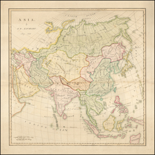
Asia is defined from the Red Sea and Turkey east to New Guinea and south to the north coast of Java. The steppes host hordes or nomadic tribes, including the Bashkirs (Baschidorum horda) and Merkit (Mecritorum horda).
In China, the former smuggling port of Lampo (Shuangyu) and the major trade cities of Ningbo (Nimpo) in Chequan (Zhejiang), Quanzu (Quanzhou), and Guanzu (Guangzhou) appear. At the site of today's Beijing is Cambalu, a corruption of Khanbaliq, which was the winter capital of the Yuan Dynasty at the time of Marco Polo's travels. Quinsai or Hangzhou, where Marco Polo reportedly visited, is shown in the northeastern reaches of China. A river connects the fictitious Cajamaj Lacus (otherwise known as Lake Chimay or Chiang Mai) to Lac Salsus (Qinghai Lake). Two ships sail east from China.
The map has a marvelous mis-projection of Japan and Southeast Asia and a very distinct Northeast Passage. The Philippines is misshapen and incomplete, lacking Luzon. Sumatra, which The Travels of Marco Polo had conflated with Java as Javor Minor, is mapped along with a Java Major and Java Minor. Tidore and Ternate, rival sultanates in the lucrative clove trade, are in the Moluccas. New Guinea, so-named by Yñigo Ortiz de Retez on the Villalobos Expedition, which occurred during Ortelius' lifetime, has some detail on its northwestern coast.
Abraham Ortelius is perhaps the best known and most frequently collected of all sixteenth-century mapmakers. Ortelius started his career as a map colorist. In 1547 he entered the Antwerp guild of St Luke as afsetter van Karten. His early career was as a business man, and most of his journeys before 1560, were for commercial purposes. In 1560, while traveling with Gerard Mercator to Trier, Lorraine, and Poitiers, he seems to have been attracted, largely by Mercator’s influence, towards a career as a scientific geographer. From that point forward, he devoted himself to the compilation of his Theatrum Orbis Terrarum (Theatre of the World), which would become the first modern atlas.
In 1564 he completed his “mappemonde", an eight-sheet map of the world. The only extant copy of this great map is in the library of the University of Basel. Ortelius also published a map of Egypt in 1565, a plan of Brittenburg Castle on the coast of the Netherlands, and a map of Asia, prior to 1570.
On May 20, 1570, Ortelius’ Theatrum Orbis Terrarum first appeared in an edition of 70 maps. By the time of his death in 1598, a total of 25 editions were published including editions in Latin, Italian, German, French, and Dutch. Later editions would also be issued in Spanish and English by Ortelius’ successors, Vrients and Plantin, the former adding a number of maps to the atlas, the final edition of which was issued in 1612. Most of the maps in Ortelius' Theatrum were drawn from the works of a number of other mapmakers from around the world; a list of 87 authors is given by Ortelius himself
In 1573, Ortelius published seventeen supplementary maps under the title of Additamentum Theatri Orbis Terrarum. In 1575 he was appointed geographer to the king of Spain, Philip II, on the recommendation of Arias Montanus, who vouched for his orthodoxy (his family, as early as 1535, had fallen under suspicion of Protestantism). In 1578 he laid the basis of a critical treatment of ancient geography with his Synonymia geographica (issued by the Plantin press at Antwerp and republished as Thesaurus geographicus in 1596). In 1584 he issued his Nomenclator Ptolemaicus, a Parergon (a series of maps illustrating ancient history, sacred and secular). Late in life, he also aided Welser in his edition of the Peutinger Table (1598).

![[ Eastern Hemisphere Globe Gores. ] (Nova et integra universi Orbis descriptio)](https://storage.googleapis.com/raremaps/img/small/54480.jpg)