


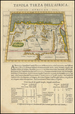
|
||

|

|
|

|
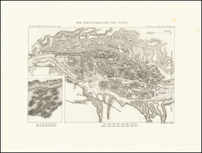
Historical Research Around the Newly-Opened Suez Canal.
This chromolithographed map, titled Carte de l'Isthme de Suez and dated January 1872, was drawn by Linant de Bellefonds Bey, a distinguished engineer and former Minister of Public Works in Egypt. The map illustrates the Isthmus of Suez as it appeared in 1858, based on Bellefonds' extensive surveys conducted from 1824 to 1855. This map was initially created for the International Commission of the Suez Maritime Canal and features notable inclusions like the route of the Hebrews' exodus from Egypt and the pursuit by the Egyptians.
Linant de Bellefonds Bey's map captures a critical period in the development of the Suez region. The mid-19th century was a transformative era for Egypt, marked by significant infrastructural and geopolitical changes, including the preliminary stages of the Suez Canal's construction. To this end, the map illustrates in red the "Premier tracé du Canal maritime de Suez" [First outline of the Suez Maritime Canal] as well as the amendment made to that route by the International Commission.
Bellefonds’ work reflects the scientific and cartographic advancements of the period and offers insights into the region's geography and history, particularly its ancient and biblical associations.
The map is enriched with two insets depicting the Red Sea's bathymetry during two distinct historical periods: the Exodus of the Israelites led by the prophet Moses in 1491 B.C., and the era of Ptolemy II Philadelphus, approximately 1207 years after the Exodus. These insets highlight the enduring interest in biblical history and the efforts to align it with geographical and historical scholarship of the time.
Prepared by Erhard and published by Arthus Bertrand, this map is a testament to the era's elaborate chromolithographic techniques, a process that allowed for more detailed and colorful map production.
![[Alexandria] Alexandrie](https://storage.googleapis.com/raremaps/img/small/81819.jpg)
![(Complete Battle of the Nile Series) Battle of the Nile, the Attack and Sunset... Plate [1] [with:] Battle of the Nile, at 10 O'Clock at Night... Plate 2d. [with:] Battle of the Nile, Near Midnight... Plate 3. [and:] Battle of the Nile, on the Ensuing Morning.](https://storage.googleapis.com/raremaps/img/small/98054.jpg)