|
||

|

|
|

|
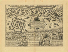
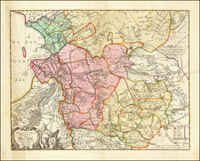
This map is the second ( reissue) state of Jacob Quack’s four sheet Maaskaart, first published in 1665. This second issue was updated by Reiner and Joshua Ottens in 1740 by reworking the original 1665 Quack copperplates to show the changing conditions in the mouth of the river Maas.
The river Maas is and was one of the main waterways accessing Rotterdam and many cities beyond along the rivers Rhine and Maas in several countries. The mouth of the river Maas was notoriously dangerous and unpredictable for seafarers.
The Ottens updated particular conditions of the additional polders created on the island Rozenburg and expanded sandbanks that created the very pronounced Hook of Holland, significant changes from the 1665 Quack issue of this map.
In 1680 Johannes van Keulen produced a two sheet map of the mouth of the river Maas that looks strikingly familiar to Jacob Quack’s Maaskaart. This was 15 years after Quack’s Octroy ( privilege ) expired. The title is Pascaert van ‘t Eylandt Roosenburgh door de Oude en Nieuwe Maes.
Jacob Quack
Jacob Quack was a mapmaker and postmaster of the city of Rotterdam. He produced with the help of engraver Joost van Geel two spectacular maps of the entrance of the river Maas, this Maasmap ( Maaskaart) and the Postmap ( Postkaart), both are on four sheets.
The Maasmap is four sheets in a row the Postmap is two sheet below and two sheet above. Each one of these maps was intended to be published surrounded with elaborate views and engravings, this never happened because of Quack’ premature death by drowning in 1668 returning from England.
The ultimate objective of the Maasmap was to promote Rotterdam as preferable port to Amsterdam. The Postmap was created to promote Quacks postal service to England and his reporting of arriving and departing vessels service to the Beurs ( Bourse) in Rotterdam. Both of these maps are rare and unique and wonderful testaments to the skill and vision of the mapmakers and engravers of the Dutch Golden Age of cartography.
The Ottens brothers, Reiner and Joshua, operated a successful printing partnership in the mid-eighteenth century (fl. 1726-1765). They began the venture in 1726, publishing maps and other prints as “R & I Ottens.” They specialized in the reprinting of others’ work, especially Guillaume De L’Isle. In 1750, Reiner died; his soon, also Reiner, took his place, but the firm began listing their works as “Joshua & Reiner Ottens.” The firm lasted until Joshua’s death in 1765. Joshua’s widow, Johanna de Lindt, sold their remaining stock of plates in 1784.
![[Gold Heightened!] Ultraiectini Dominii Tabula Multo aliis auctior et correctior per Nic. Visscher](https://storage.googleapis.com/raremaps/img/small/68994.jpg)