|
||

|

|
|

|
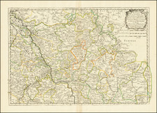
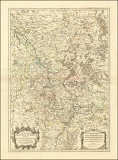
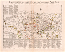
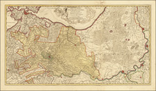
This map, primarily highlighting the Meuse or Maas River, extends its coverage to include parts of the the Rhine, Moselle, Main, and Neckar rivers, as they traverse through Northeastern France, central western Germany, an parts of the Netherlands, Belgium and Luxembourg.
The map's detailed depiction of these river systems and adjacent territories provides not only geographical information but also historical insights into the strategic importance of these regions. The inclusion of the Meuse River, for instance, points to its historical significance as a boundary and a route for trade and military movements. Similarly, the Rhine, Moselle, Main, and Neckar rivers have been pivotal in shaping the historical, economic, and cultural landscape of Western Europe.
Pierre, or Pieter, Mortier (1661-1711) was a Dutch engraver, son of a French refugee. He was born in Leiden. In 1690 he was granted a privilege to publish French maps in Dutch lands. In 1693 he released the first and accompanying volume of the Neptune Francois. The third followed in 1700. His son, Cornelis (1699-1783), would partner with Johannes Covens I, creating one of the most important map publishing companies of the eighteenth century.
![[Paris Environs - Southeast] Carte Routiere pour Automobilistes & Cyclistes -- Environs de Paris Section Sud-Est](https://storage.googleapis.com/raremaps/img/small/95862.jpg)