|
||

|

|
|

|
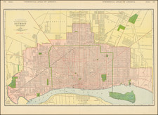
A fine example of this highly detailed map of Detroit, from Rand McNally's Indexed Atlas of the World, perhaps the best large format late 19th Century Atlas published in America.
The map paints an informative picture of the city's expansion and transformation during the 19th century. At the start of the 1800s, Detroit was primarily a small trading outpost, with its strategic location on the Detroit River making it a vital hub for the fur trade.
As the century progressed, so did Detroit, evolving from a modest settlement into a significant industrial city. This growth is clearly seen in the map, with the city's boundaries extended far beyond their early 19th-century limits. A grid of roads, both major and minor, crisscrosses the city, reflecting the city's growing urban infrastructure.
Significant landmarks, such as the Michigan State Capitol and City Hall, are clearly marked, demonstrating the city's political development. The proliferation of churches, schools, and public buildings indicates a rapidly growing population and the rise of civic society. The map also denotes numerous factories and warehouses, especially near the river and the railway lines, indicative of Detroit's burgeoning industrial sector.
Of particular note during this period was the development of urban transit lines. By 1880, Detroit had a well-established system of horse-drawn streetcars, which were later replaced by electric streetcars in the 1890s. The 1893 map clearly depicts these transit lines, which not only connected the central areas of the city but also reached out into the rapidly growing suburbs. This extensive network of urban transit played a significant role in shaping Detroit's growth, enabling both residential expansion and easy access to the city's industrial areas.
By 1900, Detroit was a city transformed. It had moved far beyond its early days as a frontier town, becoming a bustling, industrial city. Its factories produced goods for markets across the country, its streets were lined with substantial buildings and residences, and its transit system efficiently moved people throughout the city and its surroundings. The 1893 map provides a vivid snapshot of this critical period in Detroit's history, charting its remarkable growth and development during the 19th century.
Rand McNally & Co. is a large American map and navigation company best known for its annual atlases. The company got its start in 1856, when William Rand opened a print shop in Chicago. He was joined in 1858 by a new employee, Andrew McNally. Together, the men established their namesake company in 1868. Originally, the company was intended to print the tickets and timetables for the trains running to and through Chicago; their first railway guide was published in 1869.
By 1870, they had shifted from just printing to publishing directories, travel guides, and newspapers. Their first map appeared in 1872 in a railway guide. The map was produced using a new wax engraving method, a cheaper process that gave the company an edge.
By 1880 Rand McNally had entered the education market with globes, wall maps, and geography texts for students. In 1923, Rand McNally published the first Goode’s World Atlas, named after its editor, Dr. J. Paul Goode. For generations afterward, this would be the standard classroom atlas.
In 1899, William Rand left the company, but McNally and his family remained, controlling the company for over a century. In 1904, they published their first road map intended for automobiles and by 1907 were publishing Photo-Auto Guides, which combined photography and mapping to help drivers. In 1924, they produced the Auto Chum, a precursor to their famous road atlases. Rand McNally would remain the leader in road maps and atlases throughout the twentieth century.
In 1937, Rand McNally opened its first store in New York City. Ever on the frontier of technology, Rand McNally pioneered the scribing process for printing tickets in 1958 and printed their first full-color road atlas in 1960. Arthur Robinson developed his now-famous projection of Rand McNally in 1969. By the 1980s, the company was exploring digital reproduction and digital databases of maps for truckers. In the 1990s, they lead the charge to develop trip-planning software and websites. Today, most of its products are available online or in a digital format, including maps for tablets and phones.
![[ First map of Michigan Territory published in Europe ] Carte Geographique, Statistique et Historique De Michigan](https://storage.googleapis.com/raremaps/img/small/99266.jpg)
![[ Great Lakes - Upper Midwest -- Western Canada ] Partie Occidentale Du Canada, contenant les cinq Grands Lacs, avec Pays Circonvoisons](https://storage.googleapis.com/raremaps/img/small/98377.jpg)