|
||

|

|
|

|
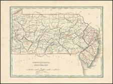
Rare Map of the Mid-Atlantic Issued Shortly After The 1783 Treaty of Peace.
A nice example of the Bowles & Carver post-Revolutionary War edition of Lewis Evans' seminal map of the British Colonies in North America, including early references to Petroleum along the Ohio River in several places on the Upper Ohio River.
Along with the maps of Henry Popple and John Mitchell, Lewis Evans map is considered among the most important and influential American maps of the 18th Century and is the only one of the three to have been published by an American. Both Evans and Mitchell's maps were intended to spur western expansion into the Trans-Allegheny, Ohio Valley and regions westward and in response to French encroachments.
Evans' map became the standard for nearly 50 years, being re-issued by Jefferys, Bowles, Kitchen and others. The map is a milestone both for its political significance and extension of cartographic knowledge in the region. Governor Pownall re-issued an updated edition of the map taken from the original Evans plate, with an addition of New England and a group of tables, naming townships in the colonies. Pownall had been a great supporter of Evans and pledged the proceeds from the map to Evans' daughter. The cartographic importance of the map and its place in the history of cartography are substantial.
The present example was published by Bowles & Carver. The most noteworthy updates on the map include:
- Completely revised title and removal of title cartouche
- Vermont appears on the map
- Completely revised cartographic details above Lake Erie
- The information on the Ottawa River has been extended much further to the West
- A western border is now shown running through Lake Huron
- Several annotations are removed or changed
This map has been described as one of the rarest editions of Evans' map.
Lewis Evans was a land surveyor and map maker who produced one of the most influential American maps of the eighteenth-century, “A general map of the Middle British Colonies” (1755). Evans was born near Pwllheli, Caernarvonshire, Wales and emigrated to the North American colonies in 1731. He found work in Philadelphia as a clerk to no less than Benjamin Franklin, who also published several of his works including the cartographic memoir that accompanied the 1755 map and a 1749 map of Pennsylvania, New Jersey, New York and Delaware. Evans was outspoken and politically active, a combination that landed him in prison in New York for libel against the Governor of Pennsylvania, Robert Hunter Morris. He died there on June 12, 1756, leaving behind a daughter, Amelia.
Amelia’s godmother was Franklin’s wife, Deborah, who raised the girl after Evans’ death. Part of Amelia’s inheritance was the plate of the 1755 map. The rest of his maps and instruments were sold at auction in early 1760. Benjamin Franklin later arranged for the plate to be sent to John Almon for reprinting in an attempt to support Amelia. This resulted in the 1776 Pownall edition of the map; however, sales were not as expected, leaving Amelia short of funds.