|
||

|

|
|

|
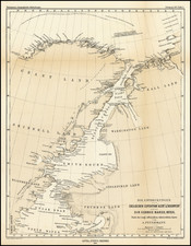
This 1828 map traces the journey of Captain John Franklin's 1825 expedition through what is now Manitoba, as surveyed by Lieutenant G. Back and Mr. E. N. Kendall. The map is notable for incorporating data from multiple sources, including Captain Bayfield's survey of Lake Superior and Arrowsmith’s map for Lake Winnipeg, offering a comprehensive view of the area during the early 19th century.
In the context of the early 19th century, this map represents a pivotal moment in the exploration and understanding of North America's northern territories. Captain John Franklin's expeditions, primarily focused on charting and studying the Arctic, played a crucial role in expanding European knowledge of these remote areas. The 1825 expedition, marked on this map, saw Franklin and his team journeying through New York, the Great Lakes, Lake of the Woods, and the Winnipeg River to reach the Arctic. This expedition was part of a series of ventures that were instrumental in mapping the uncharted territories of the Canadian Arctic, significantly advancing the geographical and scientific understanding of the region.
The map's detailing is particularly remarkable. It plots the expedition's route and camping locations and incorporates detailed geological observations. Notably, it marks the "Mountain Limestone" on the west side of Lake Winnipeg, illustrating the expedition's contribution to the geological mapping of the area. These annotations reflect the early integration of scientific methodology into the exploration and documentation of the Canadian West, a practice that was still developing during this era.

![[ Charting Hall's Quest For The North Pole ] Die Entdeckungen der Amerikanischen Nordpolar-Expedition unter Kapitan C.F. Hall 1871-1873. Reduction der vom Hydrographic Office, U.S. Navy harausgegebenen grossen Karte.](https://storage.googleapis.com/raremaps/img/small/98478.jpg)