


|
||

|

|
|

|
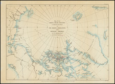
Augustus Petermann's reduced version of a larger chart initially issued by the Hydrographic Office of the U.S. Navy, mapping the exploratory forays into the North Polar regions led by Captain Charles Francis Hall over two years, emphasizing the relentless pursuit of geographical and scientific truths in the harshest of environments.
The map highlights the intricate pathways charted by Hall's expedition, presenting a detailed topography of the Arctic's formidable landscape. The regions of Grant Land, Grinnell Land, and Hall Land are prominently featured, named in honor of patrons and explorers integral to the ventures of the American North Polar Expedition. The delineation of the coasts and waterways, such as Smith Sound and Kennedy Channel, accentuates the extent of their nautical journeys and the precision of their cartographic recordings.
The scale of the map is meticulously calibrated, providing a quantifiable measure of the expanses traversed. Symbols and lines delineate the modes of transportation used, from ships to sledges, and the key routes taken by the expedition team. The map also includes annotations on the daily movements and navigational decisions, reflecting the dynamic nature of polar exploration.
Captain Charles Francis Hall was an American explorer renowned for his ventures into the Arctic during the mid-19th century. His explorations were driven by a combination of scientific inquiry, the search for the Northwest Passage, and a desire to ascertain the fate of Sir John Franklin's lost expedition. Hall embarked on three major Arctic expeditions. His first two expeditions, in 1860 and 1864, were focused on the search for evidence of Franklin's party. During these forays, he adopted Inuit survival techniques, which allowed him to travel further north than most before him, and he gathered crucial information about the region and the fate of the Franklin expedition.
His final expedition, the Polaris expedition from 1871 to 1873, was the first U.S. attempt to reach the North Pole. This journey was marked by innovation in Arctic navigation and survival strategies, but it was also beset by tragedy. Hall died under mysterious circumstances, and his team, stranded on an ice floe, endured a harrowing drift before being rescued. Despite the difficulties, Hall's expeditions significantly contributed to the mapping of the Arctic regions and to the broader understanding of the Arctic environment.
In summary, the map is a testament to the enduring human quest for exploration and the advancement of knowledge. It serves as a historical record of the formidable resolve and meticulous attention to detail that characterizes the era's spirit of exploration. This is not merely a cartographic representation but a narrative of courage, discovery, and the human condition in the pursuit of the unknown.
August Heinrich Petermann (1822-1878) is a renowned German cartographer of the nineteenth century. Petermann studied cartography at the Geographical Art-School in Potsdam before traveling to Edinburgh to work with Dr. A. Keith Johnston on an English edition of Berghaus’ Physical Atlas. Two years later he moved to London, where he made maps and advised exploratory expeditions as they set off to explore the interior of Africa and the Arctic.
In 1854, Petermann returned to Germany to be Director of the Geographical Institute of Justus Perthes in Gotha. There, he was the editor of the Geographische Mittheilungen and Stieler’s Handatlas. The Royal Geographical Society of London awarded him their Gold Medal in 1860. He continued his interest in exploration in Germany, fundraising for the German Exploring Expeditions of 1868 and 1869-70, which sought an open Arctic sea. Tragically, he committed suicide in 1878.
![[The Northern and Southern Skies] Hemisphaerii Borealis Coeli et Terrae Sphaerica Scenographia (and) Haemisphaerium Scenographicum Australe Coeli Stellati et Terrae](https://storage.googleapis.com/raremaps/img/small/78919.jpg)

![[ Jan Mayen Island ] Isola Di Mayen Scoperta l'Anno 1614 . . .](https://storage.googleapis.com/raremaps/img/small/99105.jpg)
![[Rare Second State] Poli Arctici, et Circumiacentium Terrarum Descriptio Novissima](https://storage.googleapis.com/raremaps/img/small/93127.jpg)
![[Whaling Operations] Pesca della Balena | Pesca del Pesce Sega](https://storage.googleapis.com/raremaps/img/small/78472.jpg)