|
||

|

|
|

|
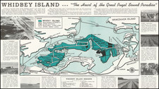
Decorative map and promotional pamphlet, promoting Tacoma and its recreational activities.
The map, coupled with photographic images, serves as a vibrant historical canvas showcasing Tacoma, Washington, from a bygone era, capturing mid-20th-century civic pride and marketing, blending cartography with visual storytelling to entice visitors and celebrate the local culture and geography.
The front side features a stylized map, highlighting the "Kla-How-Ya" trail—a welcoming phrase from the Chinook, meaning "Greetings" or "Welcome." The map is accentuated by a whimsical figure, possibly representing a native interpretation or a friendly mascot, heralding the city's attractions with a trumpeting call.
Surrounding the map are images of Tacoma, its impressive bridge infrastructure signifying progress, the untouched expanses of Puget Sound inviting exploration, and the city's industrious nature. The reverse side of the map delves further into visual exposition with a montage of photographs, each accompanied by captions that collectively serve as a testament to Tacoma's allure. It boasts of its strategic position by the majestic Mount Rainier, its pivotal role in the timber industry, and its bountiful recreation options, including fishing, boating, and mountain adventures. The images, ranging from the industrial scenes to the tranquility of mountain landscapes, provide a comprehensive portrait of Tacoma's environment and industry.

![Johnson's Washington Oregon and Idaho [Massive Dakota Territory]](https://storage.googleapis.com/raremaps/img/small/98348.jpg)
![[ Whidby Island, Washington ] Penn Cove Park: your homesite on Whidby Island. . . [with five printed photos of Whidby Island streets including four aerial shots].](https://storage.googleapis.com/raremaps/img/small/98838.jpg)