|
||

|

|
|

|
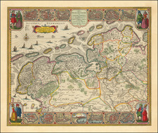
The Oldest Map of The Holy Roman Empire with Town Views
Full original color example of this rare Carte-a-figures map of the Holy Roman Empire, first published by Willem Janszoon Blaeu in Amsterdam in 1606.
Offered here is the third state of this remarkable map framed on three sides by decorative borders. First issued in about 1606, in this third state, the portrait of Rudolph II has been replaced by a portrait of Emperor Ferdinand II (1619-37), flanked by two coats of arms and eight town views, (Basel, Speyer, Nuremberg, Prague, Cologne, Vienna, Worms and Erfurt).
The full-length portraits at the left and right sides show full length portraits of the Six Electors. On the left are the three clerical Electors: the archbishops of Mainz, Cologne, and Trier; and on the right are the secular Electors: the count palatine of the Rhine, the duke of Saxony, and the margrave of Brandenburg. The portraits are drawn from the portraits engraved by Anton Wiericx for Cornelis de Jode's atlas, Speculum Orbis Terrae (Antwerp, 1593).
Willem Janszoon Blaeu (1571-1638) was a prominent Dutch geographer and publisher. Born the son of a herring merchant, Blaeu chose not fish but mathematics and astronomy for his focus. He studied with the famous Danish astronomer Tycho Brahe, with whom he honed his instrument and globe making skills. Blaeu set up shop in Amsterdam, where he sold instruments and globes, published maps, and edited the works of intellectuals like Descartes and Hugo Grotius. In 1635, he released his atlas, Theatrum Orbis Terrarum, sive, Atlas novus.
Willem died in 1638. He had two sons, Cornelis (1610-1648) and Joan (1596-1673). Joan trained as a lawyer, but joined his father’s business rather than practice. After his father’s death, the brothers took over their father’s shop and Joan took on his work as hydrographer to the Dutch East India Company. Later in life, Joan would modify and greatly expand his father’s Atlas novus, eventually releasing his masterpiece, the Atlas maior, between 1662 and 1672.
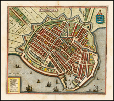
![[Haarlem] Harlemum, sive ut Ha: Barlan Her:lemum Urbs Hollandia famosa . . .](https://storage.googleapis.com/raremaps/img/small/89288.jpg)
![Carte de la Hongrie et des Pays qui en dependoient autresois dressée sur un grand nombre de memoire. . . 1703 [Map of Hungary and the countries that used to depend on it, previously drawn from a large number of records... 1703.]](https://storage.googleapis.com/raremaps/img/small/93871.jpg)