


|
||

|

|
|

|
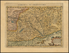
"Carte de la Hongrie et des Pays qui en dependoient autrefois" is a comprehensive map of Southeastern Europe, published by Philippe Buache in 1745. Based on the earlier work of Guillaume De L'Isle, it covers a wide array of regions including the Gulf of Venice, Greece, Macedonia, Romania, Constantinople, the Black Sea, Crimea, the Ukraine, Poland, Hungary, Transylvania, Moravia, Moldavia, the Balkans, Bulgaria, Serbia, Bosnia, Herzegovina, and Dalmatia.
Dating from the 18th century, this map reflects the evolving understanding of European geography during the Enlightenment period. Buache, a prominent French geographer and successor to De L'Isle, was known for his scientific approach to cartography, often incorporating topographical and geological information in his maps.
The geopolitical landscape portrayed in the map is a snapshot of a time when Southeastern Europe was marked by shifting borders and allegiances, particularly in the wake of the Ottoman Empire's influence. The map therefore serves as a valuable historical document, offering insights into the perceived geospatial organization of the region in the mid-18th century.
Further enhancing its appeal, the map is ornamented with decorative elements, including a detailed title cartouche, which is a testament to the aesthetics of the period. It reflects the balance between science and art that was characteristic of Enlightenment-era cartography.
Guillaume De L'Isle (1675-1726) is probably the greatest figure in French cartography. Having learned geography from his father Claude, by the age of eight or nine he could draw maps to demonstrate ancient history. He studied mathematics and astronomy under Cassini, from whom he received a superb grounding in scientific cartography—the hallmark of his work. His first atlas was published in ca. 1700. In 1702 he was elected a member of the Academie Royale des Sciences and in 1718 he became Premier Geographe du Roi.
De L'Isle's work was important as marking a transition from the maps of the Dutch school, which were highly decorative and artistically-orientated, to a more scientific approach. He reduced the importance given to the decorative elements in maps, and emphasized the scientific base on which they were constructed. His maps of the newly explored parts of the world reflect the most up-to-date information available and did not contain fanciful detail in the absence of solid information. It can be fairly said that he was truly the father of the modern school of cartography at the commercial level.
De L’Isle also played a prominent part in the recalculation of latitude and longitude, based on the most recent celestial observations. His major contribution was in collating and incorporating this latitudinal and longitudinal information in his maps, setting a new standard of accuracy, quickly followed by many of his contemporaries. Guillaume De L’Isle’s work was widely copied by other mapmakers of the period, including Chatelain, Covens & Mortier, and Albrizzi.
Philippe Buache (1700-1773) was one of the most famous French geographers of the eighteenth century. Buache was married to the daughter of the eminent Guillaume Delisle and worked with his father-in-law, carrying on the business after Guillaume died. Buache gained the title geographe du roi in 1729 and was elected to the Academie des Sciences in the same year. Buache was a pioneering theoretical geographer, especially as regards contour lines and watersheds. He is best known for his works such as Considérations géographiques et physiques sur les découvertes nouvelles dans la grande mer (Paris, 1754).
![(Second World War II - Air Navigation) Vogels Karte von Mitteleuropa [Vogel's Map of Central Europe]](https://storage.googleapis.com/raremaps/img/small/89945.jpg)
