


|
||

|

|
|

|
Stock# 99156
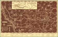
Description
The First Year of Clasen Road Maps
Rare early automobile road map of California and Nevada, published by the CMCo. (The Clasen Map Company).
This is a very early example of a Clasen road map. The maps can typically be dated by unique features in the legend (in this instance, "highly improved roads", as noted on this Clasen Map Company link.
The map identifies a number of the early named highways in California, including:
- Bankhead Highway (B.Hy)
- Coast Highway (C.Hy)
- Dixie Overland Highway (D.O.Hy)
- El Camino Real (E.C.R.)
- El Camino Sierra (E.C.S)
- Inland Route (I.Rt)
- Lincoln Highway (L.Hy)
- National Motor Express (N.M.E)
- National Old Trails Road (N.O.T)
- National Park to Park Highway (N.P.P)
- National Roosevelt Midland Trail (N.R.M)
- Old Spanish Trail (O.S.Tr)
- Pacific Highway (P.H.)
- Pikes Peak Ocean to Ocean Highway (P.P.O)
- Planked Road (P.Rd)
- Redwood Highway (R.Hy)
- Sierra Scenic Highway (S.S.Hy)
- Victory Highway (V.Hy)
![(California Oil Fields) [15 original photographs of Tupman Lease oil derricks and oil facilities at Taft, Kern County, California]](https://storage.googleapis.com/raremaps/img/small/94701.jpg)
![[ Imperial County / Annotated by County Surveyor ] Denny's Pocket Map of Imperial County](https://storage.googleapis.com/raremaps/img/small/87140.jpg)
![California and Nevada [Yosemite, Sacramento, and San Francisco Insets]](https://storage.googleapis.com/raremaps/img/small/79443.jpg)
![[Native American Indians in Southern California] Native Sites in Part of Southern California](https://storage.googleapis.com/raremaps/img/small/102006.jpg)