


|
||

|

|
|

|
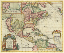
Detailed map of North America, celebrating the completion of the Transcontinental Railroad.
Published in a late edition of Brue's Atlas Universal, the map presents a detailed image of North America, with up to date treatment of the Territories in the American West and Alaska Territory (acquired from the Russians in 1867).
A tribute to the recent completion of the Transcontinental Railroad, the map illustrates not only the route of the Union Pacific and Central Pacific from Omaha to San Francisco, but also shows a a direct Railroad link beginning in Boston and traversing through New York and Philadelphia, before turning west to Chicago and on to Omaha, where it links up with the Central Pacific and on to the Pacific Ocean. As further evidence of the importance of this railraod link across North America, two Sea Routes from Europe are shown, as well as sea routes from the West Coast to Hawaii and Yokahama, serviced by railroad routes between San Francisco and Seattle, illustrating the prospect for links from Europe to Asia via North American rail.
Andre Hubert Brué was a French geographer and cartographer. Born in Paris, he served in the French Navy, joining the Baudin expedition to the Pacific (1800-1804). After his sea service, Brué applied his navigation and charting skills to creating finely-crafted maps, which were renowned for their crisp engraving and accuracy. He drew directly on the copper of the plate, creating what he called encyprotypes. He is best known for the Atlas universal de géographie physique, politique, ancienne et moderne.
![A New Map of North America Shewing its Principal Divisions, Chief Cities, Townes, Rivers, Mountains &c. Dedicated to His Highness William Duke of Gloucester [California as an Island]](https://storage.googleapis.com/raremaps/img/small/100578.jpg)

![[ Sir Edmund Halley's Observations on the Variation of the Compass ] A New and Correct Chart of the Western and Southern Oceans Shewing the Variations of the Compass According to the latest and best Observations [with text:] The Description and Uses Of A New and Correct Sea-Chart of the Western and Southern Ocean, Shewing the Variation of the Compass](https://storage.googleapis.com/raremaps/img/small/98400.jpg)