|
||

|

|
|

|
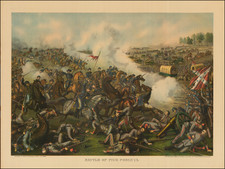
This 1895 lithograph by Julius Bien & Co., titled "Map of the United States of America, Showing Boundaries of the Union and Confederate Geographical Divisions and Departments, Dec. 31, 1860," represents an early phase in the progression of the American Civil War. As part of a set documenting the secession and conflict, this map captures the United States at a critical juncture, just before the outbreak of the war, with the seceding states indicated in a distinctive gray tint.
The map's retrospective nature, published 35 years after the events it depicts, is significant in the context of the late 19th-century American psyche. The period following the Civil War was marked by reconstruction, reconciliation, and a growing interest in the historical documentation of the conflict. This map, therefore, serves not only as a geographical representation but also as a historical narrative, encapsulating the nation's condition at the dawn of its most defining and divisive conflict.
The inclusion of various geographical features – railroads, canals, state capitals, cities, towns, and forts – provides a comprehensive view of the nation's infrastructure and settlement patterns at the time. These details are crucial for understanding the logistical and strategic considerations that would soon come into play during the Civil War.
![[All The Way With LBJ - 1964 Presidential Election Campaign Poster] Johnson Humphrey for the USA](https://storage.googleapis.com/raremaps/img/small/88907.jpg)