


|
||

|

|
|

|
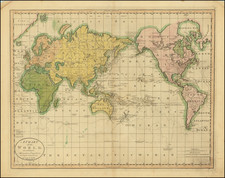
One of the First World Maps Printed In America
A good example of Carey's map of the World, showing the three voyages of Captain James Cook, each indicated with a different type of line on the map.
Van Diemen's Land is still attached to Australia and New Zealand includes a primitive shape. The NW Coast of America is still largely inaccurate and the area of Alaska and Canada above the Arctic Circle is vague and conjectural, with Cook's furtherest northern point in July 1779, noted. Several fields of ice which were encountered around the Antarctic Circle are also noted.
One of the earliest folio sized maps of the World printed in America. The map is similar to the edition which appeared in Guthrie's Geography, and may have been printed from the same plate, as there is faint evidence of erasure at the top center.
![[ World Powers - Confrontation or Relaxation? ] Weltmachte-Konfrontation oder Entspannung?](https://storage.googleapis.com/raremaps/img/small/90939.jpg)
![La Sphere Artificielle . . . 1740 [Terrestrial, Celestial & Armillary Globes]](https://storage.googleapis.com/raremaps/img/small/80300.jpg)