|
||

|

|
|

|
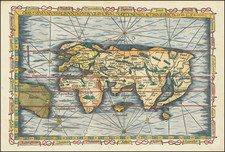
Scarce early world map ...
The map presents a simplified version of Abraham Ortelius' world map of 1570.
The map prominently shows both a Northeast and Northwest Passage.
North America bears the name of America Mexicana with an unnamed St. Lawrence River stretching far across the continent and no Great Lakes. South America is named Perviana. An unnamed Amazon reaches far across South America, nearly reaching the opposite coast. Magellan's Strait (Fretum Magelanicum) is shown.
In Asia, the Philippines islands are shown, but not named.
A massive Regionis Antarctica extends across the southern portion of the world, with only the place name of Beach noted on a portion of what would become Australia, in reference to Marco Polo's writings of his explorations.
In Africa, the Nile originates in the southern part of the continent, but without the Ptolemaic twin lake source.
![[Rare Complete Example with Game Pieces] Grand Circuit Des Capitales. Collection Concours Du Chocolat Menier](https://storage.googleapis.com/raremaps/img/small/70922rd.jpg)

![[World] Air France --](https://storage.googleapis.com/raremaps/img/small/93647.jpg)