


|
||

|

|
|

|
Stock# 99004
Description
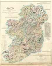
One of the first maps of Ireland Printed in America
Interesting map of Ireland, hand colored by counties.
Shows towns, roads, rivers, lakes, mountains, Islands, bays, points, etc. 32 counties named.
From the 1814 edition of Carey's General Atlas, one of the earliest large format atlases published in America. The map is among the earliest maps of Ireland printed in America.
![[Ireland / Sea Chart] Carte des Cotes Occidentales D'Irlande Reduite de la Carte de Stuart Amos Arnold et rectifee d'apres les Plans leves par M. MacKenzie Publiee Par ordres du Contr-amiral Decres Ministre de Marine et des Colonies . . . 1803](https://storage.googleapis.com/raremaps/img/small/63682.jpg)
![[Siege of Dunboy] Bere Island](https://storage.googleapis.com/raremaps/img/small/83706.jpg)
![[ Ireland ] Hyberniae Regni in Provincias Ultoniam, Connachiam, Lageniam, Momoniamq divisi Tabula Accuratisima editore Covens et Mortier Amstelo-Batavio](https://storage.googleapis.com/raremaps/img/small/99667.jpg)