


|
||

|

|
|

|
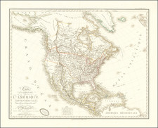
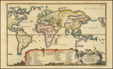
This wonderful map, produced by Heinrich Scherer in Munich in 1702, is a striking example of early 18th-century European cartographic representations of North America.
The map prominently features an insular California, a common cartographic misconception of the period, depicted as a large island. Additionally, the Great Lakes are rendered with considerable exaggeration in size, and the Mississippi River and Delta are inaccurately placed.
The interior of the continent is filled with a somewhat chaotic arrangement of mountains, rivers, and lakes, along with a speculative hint of the Northwest Passage, obscured by the ornate title cartouche. North of Santa Fe, the mythical cities of Cibola are indicated, perpetuating legends of vast riches that fueled much of the European exploration and colonial ambition in North America.
A significant vignette in the lower right of the map depicts a symbolic meeting between French, Spanish, and English explorers, each presenting a map to subjugated Native American figures. This scene artistically underscores the colonial enterprises of these European powers and their competing claims in North America. Additional decorative elements include ships representing the respective colonial fleets and fantastical sea monsters.
![L'Amerique Septentrionale divisee en ses principaux Etats…1762 [Sea of the West]](https://storage.googleapis.com/raremaps/img/small/98745.jpg)