|
||

|

|
|

|
A Foundation Stone of Empire: Captain James Biddle Takes Possession of the Columbia River Valley for the United States in 1818
A Firsthand Description by an American Sailor of the Ceremony: 21-Gun Salute Fired from the U.S.S. Ontario
With One of the Earliest Known Views of the Entrance to the Columbia River
A remarkable document of great immediacy, an American naval officer's handwritten logbook entry describing the formal taking possession by the United States of the shores of the Columbia River, undertaken by Capt. James Biddle of the U.S.S. Ontario during that ship's historic 1817-1819 voyage to the Pacific Coast.
The logbook sheet contains a brief but detailed account of the possession ceremony on August 19, 1818, held at the entrance of the Columbia River in present-day Washington State, near the boundary between Washington and Oregon. This act of possession of territory is significant in the annals of American Western expansion as a concrete and assertive act representing the nascent ambitions of a youthful United States to extend across the continent to the Pacific Ocean. The American claim had a prior basis stretching through Robert Gray, Lewis & Clark, and John Jacob Astor's Astoria fur trading settlement, though all of this had been called into question by the British capturing the mouth of the Columbia during the War of 1812. Indeed, had Biddle not reasserted the American claim on the West Coast at this moment, before the Anglo-American Convention of 1818 (signed two months later on October 20, 1818) and the Adams-Onis Treaty of 1819, the U.S. would have ceased to be a transcontinental nation.
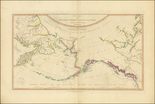
The sheet also contains a handsome original watercolor profile of Cape Disappointment at the entrance to the Columbia River - certainly among the earliest views of the Columbia River made on the spot.
At the time of the present document, the Oregon Country - comprising the present northwest coast of the United States, the southwest coast of Canada, and much of the contiguous inland region - was claimed, in whole or in part, by both the United States and Britain. The U.S. based its claim largely upon the discovery of the Columbia River by New England sea captain Robert Gray in 1792, who named the river for his ship. Gray had discovered the entrance to the river while engaged in the fur trade, and just a short time after George Vancouver had bypassed the entrance, despite the English explorer's notice of river water flowing into the ocean at the site. Historian Frederick Merk has highlighted Gray's discovery as one of the foundations of America's transcontinental empire:
This casual discovery, this accident of the fur trade, was an accident of the kind that shapes history. It established for the United States a claim to the whole valley of the Columbia; it built for the republic the foundations of empire...
A number of interrelated events in the ensuing years after Gray's accomplishment contextualize and highlight the importance of the event recorded in our document. Historian Merk succinctly describes the path to American dominion in the Pacific Northwest:
A contest of exploration, colonization, and diplomacy in the Pacific Northwest followed the discovery of the Columbia. It followed not at once, but as soon as the American people had caught a glimpse of their destiny on the Pacific Ocean. In 1803 the United States acquired the province of Louisiana. By this coup of diplomacy the republic extended its boundaries to the crest of the Rocky Mountains and strengthened, through the principle of contiguity, the claim it had to the territory west of the mountains. In 1805-1806 the Lewis and Clark expedition explored and mapped the middle tributaries of the Columbia and the main river from its junction with the Snake to the sea. In 1811-1812 John Jacob Astor, at the head of the Pacific Fur Company, built Astoria at the mouth of the Columbia and other trade posts on the upper waters of the river. These measures broadened the claim of the United States to the Columbia Valley. They added to American rights arising from Gray's discovery those of contiguity, systematic exploration, and occupation - Merk, "The Genesis of the Oregon Question."
Following the War of 1812 pressure mounted within the governments of the United States and Great Britain to solidify respective claims to territory in the region, especially given Spain's diminished control of her erstwhile Pacific coast empire. The Treaty of Ghent, which ended the war, made no changes to the prewar boundaries on the U.S.-Canada border, entitling the U.S. to the same position on the Columbia that it has formerly held, including, at least in the view of the United States, the restoration of Astoria, which had been captured by the British during the war (Astor having extracted himself by selling his interests to the North West Company).
Biddle and U.S.S. Ontario: 1817-1818.
As part of the diplomatic repercussions of the Treaty of Ghent, Secretary of State John Quincy Adams, an avid expansionist, tasked John B. Prevost, serving in the capacity of executive agent for the government, to secure the Oregon Territory as reparations from the British for the War of 1812. As part of the plan, in September 1817, Captain James Biddle was given orders to prepare the sloop of war Ontario for a voyage to Columbia. The two were directed, "by some symbolical or appropriate mode adapted to the occasion" to make a claim on behalf of the United States to the valley of the Columbia. As it happened, Prevost was not present to conduct such a possession ceremony, having been distracted by tasks in Valparaiso, but Biddle forged ahead to the Northwest anyway:
Biddle reached Cape Disappointment on August 19. He deemed it not prudent to cross the bar. Instead, he anchored on the ocean side and proceeded in with three boats manned by fifty officers and men. On the river's north bank, in the presence of his crew and a group of puzzled Chinook Indians, he took possession of the country - Merk.
Biddle's own account of the possession ceremony, transcribed below from his logbook presently held in the Library of Congress, is useful for providing supportive context for our document. It is also interesting to note that Biddle conducted the act of possession in the presence of several Native American witnesses, and even visited a local Indian chief soon after the ceremony.
I sailed from Lima on the thirtieth of June (1818) and arrived off the Columbia River on the nineteenth of August at daylight. The entrance to this river is rendered difficult to vessels so large as the Ontario by the shoalness of the water on its bar, by its sinuous channel, and by the strength and irregularity of its tides. As it was not indispensable to the service I had to perform that the ship should enter the river, I anchored outside the bar, and proceeded in with three boats well armed and manned with more than fifty officers and seamen. I landed at a small cove within Cape Disappointment on the north side of the river, and here, in the presence of several of the natives, diplaying the flag of the United States, turning up a sod of soil, and giving three cheers, I nailed up against a tree a leaden plate in which were cut the following words:
Taken possession of in the name and on behalf of the United States, by Captain James Biddle, commanding the United States Ship Ontario, Columbia River, August, 1818.
While this was passing on shore, the ship fired a salute. When this ceremony was concluded, I proceeded up to Chinoake village and visited its chief, thence crossed the river and visited the settlement which is 20 miles from Cape Disappointment, and on my way down the river I landed on its south side near Point George and took possession. I anchored with the boats.
Soon after these actions at the Columbia Biddle headed to Monterey for much needed supplies, where he noted the presence of the Russian sloop of war Kutusoff.
On August 19, 1818, Biddle also wrote to secretary of state John Quincy Adams, from on board the Ontario:
Sir: I have the honor to inform you I have this day taken possession, in the name and on behalf of the United States, of both shores of the river Columbia; observing in the performance of this service the ceremonies customary upon the like occasions of setting up a claim to national sovereignty and dominion. I have the honor to be with great respect, sir, Your most obedient servant, J. Biddle
Anglo-American Convention of 1818
The wording of Biddle's letter to Adams, "of setting up a claim to national sovereignty and dominion," is significant given the context of the 1818 negotiations with Great Britain which established a temporary joint possession of the Oregon Country.
John Quincy Adams, Secretary of State under President James Monroe from 1817 to 1825 had a significant role in formulating the foreign policy of the United States, and played a crucial part in the negotiations of the 1818 agreement with Great Britain for the joint occupation of the Oregon Country, and the establishment of the U.S.-Canada border along the 49th parallel in the Convention of 1818.
The United States and Great Britain agreed to the 49th parallel north boundary line mostly because a straight-line boundary would facilitate a survey more than pre-existing boundaries based on watersheds. The treaty marked Britain's last permanent major loss of territory in what is now the Continental United States. The British ceded all of Rupert's Land south of the 49th parallel and east of the Continental Divide, encompassing all of the Red River Colony, south of that latitude. For its part, the United States ceded the northernmost edge of the Missouri Territory, north of the 49th parallel.
While the United States did not take formal possession of any territory in the Pacific Northwest in 1818, the agreement made in 1818 between the United States and Great Britain was essentially a treaty of joint occupation of the Oregon Country and Pacific Northwest region.
The agreement allowed citizens of both the United States and Great Britain to reside in and access the Oregon Country without any change to the territorial claims of either nation. It was a practical solution to the ongoing dispute over the region, allowing both countries to operate in the area without resolving the issue of sovereignty. This arrangement was renewed in 1827 and continued until the Oregon Treaty of 1846, which finally established the 49th parallel as the boundary between British and American territories in the Pacific Northwest. It was through this treaty in 1846 that the United States formally took possession of its portion of the Oregon Country.
The 1818 boundary agreement concerning the Pacific Northwest marked a pivotal moment in the territorial history of the United States, involving a vast swath of the West, stretching from the Rocky Mountains to the Pacific Ocean, and from California's northern border to Alaska's southern edge. This region was already of significant strategic and economic importance in the early 19th century. Multiple nations, including Spain, Russia, Great Britain, and the United States, had attempted to lay claim to parts of this territory. However, by the mid-1820s, only Britain and the United States remained as the primary competitors for the region.
The Oregon Country was coveted for several reasons. First, it offered access to the Pacific Ocean, which was crucial for trade and military strategy. Additionally, the region was rich in natural resources, including fur, which was highly valued at the time. The British, through the Hudson's Bay Company (HBC), had a strong presence in the area, establishing trade posts and building relationships with indigenous populations. They particularly valued the Puget Sound for its excellent harbor and strategic location. The Americans, on the other hand, had lacked a significant presence in the Pacific Northwest. Their population was primarily located east of the Mississippi River, and their navy and colonial reach were not as extensive as Britain's. However, the United States was interested in expanding westward and saw the Oregon Country as a critical step in this expansion, especially for securing a Pacific coast harbor from which it could dominate trade in the Pacific.
The boundary discussions initially revolved around the 49th parallel, with the British expecting this line to continue westward, allowing them access to the Columbia River and control over Puget Sound. The Americans, while not expecting to gain territories north of the 49th parallel, were keen on acquiring Puget Sound and access to the Strait of Juan de Fuca, recognizing the lack of good harbors on the Pacific coast within their territory. The subsequent negotiations and shifts in power dynamics, including the relocation of HBC's headquarters, indicated a gradual shift in favor of American interests.
Despite the relatively friendly nature of the agreement of 1818, it precipitated a protracted struggle over the control of the Oregon Country during the following two decades. The British Hudson's Bay Company, whose network of trading posts on the lower Columbia River, including forts in what is now eastern Washington state as well as on the Oregon Coast and in Puget Sound, undertook efforts to restrict the activities of U.S. fur traders in the area. In the 1830s pressure mounted in the U.S. to annex the region outright.
By the mid-1840s, the growing force of Americans answering the call to head west, as well as a U.S. political movement intent on claiming the entire territory as part of Manifest Destiny, led to a renegotiation of the agreement. In the end, the Oregon Treaty of 1846 permanently established the 49th parallel as the boundary between the United States and British North American to the Pacific Ocean.
Watercolor of Cape Disappointment
It is interesting to note that Bruno de Hezeta, sailing for Spain, had discovered the Columbia River in August 1775, some years before Robert Gray's fortuitous arrival there. Indeed, Hezeta became the first to map and write a description of the entrance to the Columbia River, which he named Bahia de la Asunción. Hezeta also bestowed the name of Cavo de San Roque to the site we know today as Cape Disappointment, which is depicted on the present sheet in a neat original watercolor completed on the spot by an American sailor in 1818.
The English name for the location derived from the sense of disillusionment experienced there in 1788 by British fur trader John Meares. The Englishman had been searching for a river rumored to flow into the Pacific Ocean. But likely due to the treacherous bar at the river's mouth, which tended to hide the river's entrance from the sea, he concluded incorrectly that no such river existed. He named the headland "Cape Disappointment" to reflect his frustration and disappointment at not finding the river that, unbeknownst to him, Hezeta had already seen and noted for the Spanish government.
Here follows the text of the present document, including the firsthand description of the 21-gun salute "in celebration of taking possession of the territory":
[Watercolor profile of Entrance of Columbia River, with blue wash color, captioned in manuscript as follows:]
Entrance of Columbia River. A. Cape Disappointment N. 49.° East. 8 miles. B. Tongue Point N. 75° E. 25.
Remarks. Thursday. August 20th 1818
Remarks.
Wolsey [apparently the name of the American officer who recorded the action of the day]
Commences with moderate breezes from the South & West at 1 P.M. Fired a Salute of 21 Guns in celebration of taking possession of the territory at 3. loaded, & received the Guns, from 4. to 8. moderate breezes from the North, & West, if hazy, from 8. to 12. fresh breezes from the West & Cloudy at 9. 10. & 12. fired Guns, & discharged Rockets every 15 minutes. From 12. to 4. A.M. moderate winds, with thick hazy weather, from 4. to 8. thick hazy weather, with light airs at 8. the boats returned, having been obliged to abandon two spars, on account of the breakers. From 8. to 12. cloudy with fresh winds from the South, & East. at 9. hoisted in the boats, got under way, & stood to the North, & East, under single reef'd top sails in search of the spars left by the boats at 10. Cape Disappointment bow S.E. dist. 8 miles, haul'd by the wind on the Larboard tack, & made sail. Unbent Cables, & secured the Boats, at 10.30, sent down top gale yards unbent flying jib. Weather thick.
Summary
The act of possession recorded herein renders this sheet tangible evidence of an early assertion of power and dominion by the United States in the Pacific Northwest. In a real sense Biddle's 1818 act of possession and the subsequent Convention of 1818 with Great Britain set the stage for the later Oregon Treaty of 1846, which ultimately resolved the boundary dispute between the U.S. and Great Britain. There is no mistaking that the 1818 agreement laid the groundwork for the later resolution of the boundary and represented a crucial moment in the expansion of the United States and the shaping of its modern borders.
Rarity
Original manuscript material from the 1817-1818 voyage of the Ontario is very rare in both the market and within institutional confines. While the Library of Congress and the National Archives hold such items as Biddle's own logbooks and journals, official muster rolls for the ship, and related official state documents such as correspondence between Capt. Biddle and the Secretary of State, firsthand manuscript evidence recording this important official action - a claim by the United States for the Columbia River Valley and a swath of the Pacific Coast of North America - very rarely appears for sale. Such documentation as our logbook sheet, written by an eyewitness, is of superlative historical interest. One would be hard put to imagine a similar artifact accessible to private ownership connected with this too-little studied yet key moment in American western expansion.
Provenance
Jenkins Company. Catalogue 175 (1982), item 1521. Listed for $1850.
![[Map of the United States, illustrating the routes of the Canadian Pacific Railway and the Seattle, Lake Shore and Eastern Railway]](https://storage.googleapis.com/raremaps/img/small/71080.jpg)