|
||

|

|
|

|
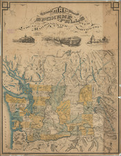
Bellingham At The Beginning of the Boom of the 1890s
Rare separately published map of Bellingham and Environs, published by W.H. Whitney.
Centered on Bellingham, the map covers the area from Chuckanut and Lake Samish to today's Dewey, Cordata and the Bellingham Airport.
The large inset shows the route of the Union Pacific Railroad in the north part of Puget Sound, covering the San Juan Islands and parts of Whatcom and Skagit Counties. Railroad lines shown in the map include:
- Fairhaven & Southern RR
- Fairhaven & Northern RR
- Bellingham Bay & British Columbia RR Co.
Several dozen subdivisions and additions are shown in color.
The map is one of several maps published by WH Whitney in conjunction with the Union Pacific Railroad, which would in term be given to land agents working with the Union Pacific (here Fred C. Pettibone & Co. of Whatcom) and Pettibone & Belding & Co. of Fairhaven). Because the maps were separately issued for promotional purposes and not generally offered for sale, they are now very rare.
Rarity
The map is very rare. No examples have appeared at auction or in dealer catalogs reported by RBH or AMPR.
We note examples in the collection at Harvard University, Western Washington University and Bellingham Public Library.