|
||

|

|
|

|
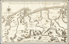
Haiti on the Eve of Revolution
A fine 18th-century map of Cap-Haïtien, the historical capital of Haiti.
Cap-Haïtien, then called Cap-Français (or Cap-Francois), was the capital of the French colony of Saint-Domingue (Haiti), from the time of its founding in 1711 until 1770. During this period, Saint-Domingue was one of the most economically productive places in the world, owing to it flourishing sugar industry.
As evident on the map, the city was laid out on a neat geometrical grid, following Enlightenment precepts. The town was, and is still dominated by the Cathedral of Notre-Dame de Cap-Haïtien, the largest church in Haiti.
The present map was issued by Thomas Jefferys in London to capitalize of the great interest in French and Spanish ports owing to the ongoing Seven Years' War (1756-1763). Due to it's key role in the French colonial system, Cap-Haïtien was a prime proposed target for an attack by Britain's Royal Navy, although it was passed over in favor of more easily-conquerable French possessions, such as Martinique and Guadeloupe.
In the 18th century, Saint-Domingue, as it was then known, was a French colony and one of the most prosperous in the Caribbean due to its production of sugar, coffee, and indigo, cultivated by enslaved Africans. Cap-François (now Cap-Haïtien) was the economic heart of the colony and a key location in the Atlantic trading system.
The Haitian Revolution began in 1791 and was a direct response to the brutal conditions under French colonial rule. The initial leader of the uprising was a vodou houngan (priest) named Dutty Boukman, and the first major conflict was the Battle of Bois Caïman. The revolution was further galvanized by leaders like Toussaint L'Ouverture, a former slave who became the most prominent leader of the revolution, and Jean-Jacques Dessalines, who continued the fight after Toussaint's capture by the French in 1802.
The conflict saw various shifts in control and allegiances, with Spanish and British forces also attempting to take advantage of the unrest to seize control of parts of the colony. Key battles during the revolution include the Siege of Fort Dauphin (1793), the Battle of Crête-à-Pierrot (1802), and the Battle of Vertières (1803). The latter, near Cap-François, was a decisive conflict leading to the French defeat.
The Haitian Revolution culminated in 1804 with the declaration of independence by Dessalines, who proclaimed the former colony as the independent nation of Haiti. This was a monumental event as it marked the first successful slave revolt in modern history and led to the establishment of the first black-led republic in the world, and the second independent nation in the Americas after the United States.
Thomas Jefferys (ca. 1719-1771) was a prolific map publisher, engraver, and cartographer based in London. His father was a cutler, but Jefferys was apprenticed to Emanuel Bowen, a prominent mapmaker and engraver. He was made free of the Merchant Taylors’ Company in 1744, although two earlier maps bearing his name have been identified.
Jefferys had several collaborators and partners throughout his career. His first atlas, The Small English Atlas, was published with Thomas Kitchin in 1748-9. Later, he worked with Robert Sayer on A General Topography of North America (1768); Sayer also published posthumous collections with Jefferys' contributions including The American Atlas, The North-American Pilot, and The West-India Atlas.
Jefferys was the Geographer to Frederick Prince of Wales and, from 1760, to King George III. Thanks especially to opportunities offered by the Seven Years' War, he is best known today for his maps of North America, and for his central place in the map trade—he not only sold maps commercially, but also imported the latest materials and had ties to several government bodies for whom he produced materials.
Upon his death in 1771, his workshop passed to his partner, William Faden, and his son, Thomas Jr. However, Jefferys had gone bankrupt in 1766 and some of his plates were bought by Robert Sayer (see above). Sayer, who had partnered in the past with Philip Overton (d. 1751), specialized in (re)publishing maps. In 1770, he partnered with John Bennett and many Jefferys maps were republished by the duo.
![Culiacanae, Americae Regionis, Descriptio [with] Hispaniolae, Cubae, Aliarumqe Insualrum Circumiacientium Delineatio](https://storage.googleapis.com/raremaps/img/small/86114.jpg)
![[Haitian Revolution] Carte de la Partie Francoise De St. Domingue . . . / A Map of the French Part of S. Domingo . . .](https://storage.googleapis.com/raremaps/img/small/85056.jpg)