


|
||

|

|
|

|
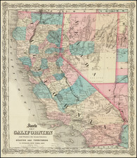
One of the Earliest Detailed Maps of Northern California
Marvelous regional map, centered on San Francisco, extending to just south of Monterey and north to Cape San Sebastian, published by Philippe Vandermaelen in Brussels for his 1827 publication Atlas Universel de Geographie Physique, Politique, Statistique et Mineralogique.
Vandermaelen's map is the earliest obtainable regional map to focus on the Northern California Coastline. The coastal mountain ranges are treated with remarkable detail for the period, with populations given for the few populated regions around the missions, including:
- San Francisco (820)
- San Jose (630)
- Santa Clara (1300?)
- Santa Cruz (440)
- San Juan Batiste (960)
- Monterey (700)
- La Soledad (570)
Over a dozen place names are given, including a note that the Rio Sacramento is navigable for another 50 leagues from the point shown.
From Vandermaelen's remarkable 6 volume atlas, which if combined as globe gores, forms an immense globe. Vandermaelen accomplished the first atlas mapping of the world on a uniform scale. His treatment of Western North America is a landmark in the history of the cartography of the western extent of the continent.
Translation
An inset on the top right from German geographer, naturalist, and early traveler of North America Alexander von Humboldt describes the region as such:
NEW CALIFORNIA. The part of the coast of the Great Ocean, which extends from the isthmus of Old California, or Bay of Todos los Santos (south of the port of San Diego) to Cape Mendocino, is named on the maps since the Spanish era as New California. It is a long and narrow stretch of land on which, for forty years, the Mexican government has established missions and military posts. There are no villages or even a single farm north of the port of Saint Francis, which is more than 78 leagues from Cape Mendocino. The province of New California, in its current state, is only 197 leagues long and about 10 leagues wide. The city of Mexico is in a straight line at the same distance from Philadelphia as from Monterey, which is the head of the missions of New California, and whose latitude is within four minutes of that of Cadiz. As much as the soil of Old California is arid and rocky, that of New is watered and fertile. It is one of the most picturesque countries one can see. The climate there is much milder than at the same latitude on the eastern coasts of the new continent. The sky is foggy, but the frequent fogs that make landing on the coasts of Monterey and San Francisco difficult give vigor to the vegetation and fertilize the soil, which is covered with black and spongy humus. In the eighteen missions that exist today in New California, wheat, corn, and beans (frijoles) are abundantly cultivated. Barley, vetches, lentils, and chickpeas (garbanzos) grow very well in most parts of the province, amid the fields. Since the thirty-six Franciscan religious who govern these missions are all Europeans, they have introduced with particular care, into the gardens of the Indians, most of the vegetables and fruit trees that are cultivated in Spain. The first settlers who arrived in 1769 already found in the interior of the country wild grapevines, which produce quite large but very sour bunches of grapes. It was perhaps one of the many species of Vitis native to Canada, Louisiana, and New Biscay, which botanists still know only imperfectly. The missionaries have established in California the Vitis vinifera vine, which the Greeks and Romans spread throughout all of Europe, and which is certainly foreign to the new continent. Good wine is made in the villages of San Diego, San Juan Capistrano, San Gabriel, San Buenaventura, Santa Barbara, San Luis Obispo, Santa Clara, and San Jose, therefore all along the coast south and north of Monterey up beyond the 37th latitude. The European olive tree is successfully cultivated near the channel of Santa Barbara, especially near San Diego where they make an oil that is as good as that of the valley of Mexico (from Humboldt).
Philippe Marie Vandermaelen (1795-1869) was a Belgian cartographer and geographer known for his pioneering use of technology and his leadership in establishing the important Establissement geographique de Bruxelles. Born in Brussels, Philippe was obsessed with maps from a young age. He taught himself mathematics, astronomy, and mapmaking and plotted the battles of the Napoleonic wars avidly. He took over his father’s soapmaking business briefly in 1816, but then turned it over to his brother in favor of cartography.
From 1825 to 1827, he released his first atlas, the Atlas universal, which was well received. It was sold in forty installments of ten maps each, with 810 subscribers listed. The atlas contained 387 maps in six volumes at a uniform scale of 1:1.6 million. The maps were intended to be joined and together would create a globe 7.755 meters wide. It was the first atlas to show the entire world on a large uniform scale and was the first atlas produced using lithography. This project served as Vandermaelen’s gateway into intellectual life, gaining him membership in the Royal Academy of Sciences and Belles-Lettres of Brussels (1829).
In 1830, Vandermaelen inherited a laundry from his parents which he converted into the Establissement geographique de Bruxelles, or the Brussels Geographical Establishment. His brother, Jean-Francois, also established a botanical garden on the site. The Establishment had its own lithographic press, one of the first to use the technology for cartography and the first in Belgium. They produced textbooks, surveys, and especially maps of Brussels to be used for urban planning. The complex also housed schools, an ethnographic museum, and a library open to the public. Vandermaelen was passionate about geographic education and saw the Establishment as an open place where people could learn about the world.
In 1836, he was knighted for his services to geography and the intellectual community of Belgium. He died at age 73 in Molenbeek-Saint-Jean, near the Geographical Establishment that he founded. After Vandermaelen’s death, the Geographical Establishment declined, closing its doors in 1880. The extraordinary collection they had amassed passed to several institutions, most importantly the Royal Library of Belgium.
![[ San Francisco Bay Entrance ] Vue de l'entrée de la Baie de San-Francisco (haute Californie.)](https://storage.googleapis.com/raremaps/img/small/102952.jpg)
![[Imperial Valley]](https://storage.googleapis.com/raremaps/img/small/69292.jpg)