|
||

|

|
|

|
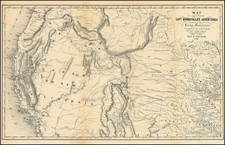
Includes Future Site of Douglas Refinery
A chart illustrating the expanding oil and gas industry of Kern County, California. This chart shows the status of wells and pipelines, their given names, and the company that owns the well. Some recognizable names and companies appear on this map, namely the Hershey Family Oil Trust, the Standard Oil Company, and Shell Oil. These industry titans are joined by smaller competitors who own wells in various stages of operation in the area.
The annotations, which shows countour lines, roads, some possible pipelines and the location of the Douglas Refinery at the lower left, just off the Southern Pacific Railroad line.
The chart is quite detailed in displaying the different states of wells. Broadly, they fall into uncompleted and completed with specific designations for if they are abandoned, drilling, idle, or producing, including:
- Uncompleted drilling
- Uncompleted idle
- Uncompleted abandoned
- Completed producing
- Completed idle
- Completed abandoned
- Water
- Uncompleted abandoned converted to water
- Completed abandoned converted to water
- Gas
- Gas abandoned
Many oil wells are depicted throughout the map. This region appears to be one of the most profitable areas of Kern with hundreds of wells either producing or planned depicted throughout the area.
Condition Description
![[ San Diego County / Julian Mining District ] Sixth Annual Report of the State Mineralogist. Part I for the year ending June 1st 1886.](https://storage.googleapis.com/raremaps/img/small/101709.jpg)
![(California Oil Fields) [15 original photographs of Tupman Lease oil derricks and oil facilities at Taft, Kern County, California]](https://storage.googleapis.com/raremaps/img/small/94701.jpg)
![(Southern California Aerial Photographs) [Collection of 9 Aerial Photographs of San Fernando Valley, Van Nuys, and Burbank]](https://storage.googleapis.com/raremaps/img/small/94783.jpg)