|
||

|

|
|

|
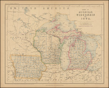
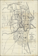
The Rarest Atlas Map of Wisconsin Territory
Gorgeous example of this early map of Wisconsin Territory, issued in 4 years prior to statehood.
Includes an appearance of Richland County, which was founded on February 18, 1842.
The lands south of the Wisconsin and Fox Rivers are largely surveyed and many early counties, towns, etc. appear. The region to the north is dominated a massive Brown County, Crawford County and St. Croix County. Portage, Chipewa and Lapoint are not yet established. These lands of the Winnebagos, Menomonies, Oneidas, Sioux New York and Chippewa Indians are shown prominently. Massive Carver claim remains, now nearly 100 years old.
The south is filled with roads, and towns, the north rivers, portages, etc.
Tanner's New General Atlas was issued following Tanner's sale of his Universal Atlas to Samuel August Mitchell. The Universal Atlas, which had been published in Philadelphia from 1836 to 1845. Tanner's New General Atlas, for which Anthony Finley was also a collaborator, is one of the rarest 19th Century American atlases. To view the complete atlas in the David Rumsey collection, click here.'
Wisconsin Territory
The period between the creation of the Wisconsin Territory in 1836 and the year 1844 was a formative time in the region's history, characterized by significant changes in territorial boundaries and governance. The Wisconsin Territory was established on July 3, 1836, from land previously included in the Michigan Territory. This occurred shortly before Michigan was admitted to the Union as a state.
Initially, the boundaries of the Wisconsin Territory extended far beyond the borders of the present-day state, including parts of what would become Iowa, Minnesota, and portions of the Dakotas. However, the region was soon to undergo a redefinition of its borders. In 1838, the region to the west of the Mississippi River was detached to form the Iowa Territory, thus shrinking the Wisconsin Territory considerably.
During this period, the territorial capital moved several times, reflecting the rapid development and shifting population centers within the territory. Belmont, Mineral Point, and finally Madison served as the capitals, with Madison being designated the capital in 1838 due to its central location. The first territorial legislature met in Belmont in 1836, where they began the work of establishing a legal and administrative framework for the territory.
Rarity
The map is very rare. This is the first example we have ever seen on the market.
![[Wisconsin] General Map of the Lead Region Showing the Distribution of the Lodes . . . By James Wilson, Jr. 1880](https://storage.googleapis.com/raremaps/img/small/59314.jpg)