|
||

|

|
|

|
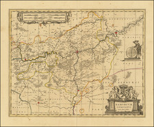
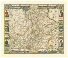
Detailed map of the modern Netherlands less the southern part of Limburg, first published in Amsterdam in 1658.
The map includes an ornate cartouche, featuring allegorical figures and classical iconography typical of the period's cartographic aesthetics. A winged figure, possibly representing Fame or Victory, blows a trumpet, signifying the announcement or celebration of the federated provinces' might and unity. The central shield bears the lion rampant, a heraldic symbol associated with the Low Countries, set against a background of luxuriant drapery held by figures embodying strength and vigilance, indicated by the fasces and the vigilant pose.
Below the shield, a serene figure sits atop a globe, perhaps symbolizing the Dutch Republic's global reach and influence during its Golden Age, a period of prosperity and cultural flowering. To the left, a cherub or putto writes on a tablet, signifying the recording of history or law, while another putto to the right of the shield appears to hold a level, a symbol of balance and justice.