


|
||

|

|
|

|
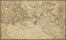
Klondike Gold Rush-Era Map of Alaska Detailing The Routes To the Gold Regions
Important early Gold Rush era of Alaska, produced in a collaboration between the General Land Office and the U.S. Coast & Geodetic Survey,
Following the discovery of gold in Alaska, the year 1897 saw a rush of miners to the Klondike regions of Alaska, one of America's most remote frontiers. Unlike prior gold rushes in California, Colorado, Nevada, Idaho and Montana, the journey to Alaska was complex and required a rugged mix of travel by sea and through difficult stretches of the backcountry of Alaska and the Yukon under unfavorable conditions not seen since the first '49ers crossed the Transmississippi West. While a host of privately published maps of Alaska and the Gold Regions issued in 1897 purported to offer guidance, it was not until this map was published in 1898 that the United States government produced a comprehensive and detailed overview of the options available to prospective gold miners.
The primary map, complete with isothermal lines, provided an exceptional overview of the region, with gold discoveries colored yellow other mineral regions noted and the primary routes available highlighted in red. The large inset at the top left focused on the area between Juneau and the gold diggings, was by far the largest scale and most detailed treatment of the region, published for the second major transit season and relaying to travelers the benefit of the earliest detailed reports on the viability (or lack thereof) of the available routes.
This map delineates not only the topographical contours of the region but also indicates the burgeoning infrastructural developments, mineral deposits, and a detailed representation of the Aleutian Islands.
In the late 19th century, Alaska transitioned from a remote territory to an area of economic interest for the United States, especially following the Klondike Gold Rush of 1897. The attendant influx of settlers and prospectors necessitated detailed cartographic records to navigate the vast and often treacherous Alaskan landscapes. This map vividly demonstrates the rush to capitalize on the territory's resources, indicating regions of reported gold discoveries, silver, copper, and coal deposits. Routes to the interior, both by water and overland, reflect the means by which these regions could be accessed, while the timber limits suggest areas of potential commercial logging.
The map enumerates eleven different mission denominations, such as Episcopalian, Greek Catholic, Swedish Evangilical (sic.), Moravian, and Methodist Episcopal. Underscoring the ongoing cultural and societal transformations of the era.
The inset titled From Juneau to Forty Mile Creek emphasizes a pivotal corridor during the late 19th-century Klondike Gold Rush. Situated between Juneau, Alaska's capital, and Forty Mile Creek, a primary Yukon mining area, this region was a nexus of transportation and trade for prospectors, traders, and officials. By providing a detailed view of this area, the map underscores its economic and historical significance during a transformative period in Alaska, capturing the essence of exploration, ambition, and rapid development spurred by the gold rush.
The General Land Office (GLO) refers to the independent agency in the United States that was in charge of public domain lands. Created in 1812, it assumed the responsibilities for public domain lands from the United States Department of the Treasury. The Treasury had overseen the survey of the Northwest Territory, but as more area was added to the United States, a new agency was necessary to survey the new lands.
Eventually, the GLO would be responsible for the surveying, platting, and sale of the majority of the land west of the Mississippi, with the exception of Texas. When the Secretary of the Interior was created in 1849, the GLO was placed under its authority. Until the creation of the Forest Service in 1905, the GLO also managed forest lands that had been removed from public domain. In additional to managing the fees and sales of land, the GLO produced maps and plans of the areas and plots they surveyed. In 1946, the GLO merged with the United States Grazing Service to become the Bureau of Land Management.
![[Collection of 10 manuscript charts and maps depicting the west coast of North America from Monterey, California, to just north of Salisbury Sound, Alaska.]](https://storage.googleapis.com/raremaps/img/small/98898.jpg)
![[ California To Alaska -- Northwest Passage ] Quivirae Regnu cum alijs versus Borea](https://storage.googleapis.com/raremaps/img/small/60083.jpg)
![Naufrage De M.M. De Laborde Sur Les Canots De La Peyrouse Au Port Des Francois Dans La Californie . . . [Shipwreck of the Astrolabe's yawl at Port des Francais, Lituya Bay, Alaska]](https://storage.googleapis.com/raremaps/img/small/52480.jpg)
![[Nome Gold Rush] Map of Seward Peninsula The Arctic Gold Fields of Alaska Showing Precinct Boundaries, Recording Offices, Post Offices, Trails & Road Houses . . . December 1903](https://storage.googleapis.com/raremaps/img/small/76156.jpg)