|
||

|

|
|

|
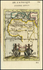
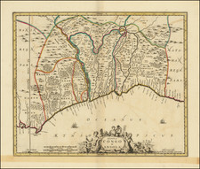
An intriguing piece from the Age of Exploration, this map, "Negroland and Guinea. with the European settlements, Explaining what belongs to England, Holland, and Denmark &c. . . ." was created by Herman Moll and published in London in 1728. The map depicts West Africa, spanning from Senegal to Gabon, and stands as a testimony to the early 18th-century understanding of African geography.
The period of the map's creation was characterized by expanding European colonial interests in Africa. The detailed delineation of territories—highlighting those belonging to England, Holland, and Denmark—serves as a stark indicator of these colonial pursuits. Moll's map provides a snapshot of the geopolitical landscape of the time, reflecting the intense competition among European powers for control over valuable resources and trade routes.
A noteworthy feature of the map is its use of the term "Negroland," a term indicative of the racial attitudes of the time and which appears to have been in use only during the second quarter of the 18th century. This uncommon nomenclature, along with the specific labeling of the Gold Coast, Slave Coast, Grain Coast, and "Bennin," offers insight into the social and economic factors that drove European interest in West Africa, notably the transatlantic slave trade and the pursuit of gold and other commodities.
Moll's "Negroland and Guinea" is a profound artifact of its time, embodying the tensions and aspirations of the Age of Exploration. As a cartographic record, it provides a fascinating lens through which to examine the complexities of European colonial endeavors, the racial ideologies of the period, and the rich history of West Africa itself.
Herman Moll (c. 1654-1732) was one of the most important London mapmakers in the first half of the eighteenth century. Moll was probably born in Bremen, Germany, around 1654. He moved to London to escape the Scanian Wars. His earliest work was as an engraver for Moses Pitt on the production of the English Atlas, a failed work which landed Pitt in debtor's prison. Moll also engraved for Sir Jonas Moore, Grenville Collins, John Adair, and the Seller & Price firm. He published his first original maps in the early 1680s and had set up his own shop by the 1690s.
Moll's work quickly helped him become a member of a group which congregated at Jonathan's Coffee House at Number 20 Exchange Alley, Cornhill, where speculators met to trade stock. Moll's circle included the scientist Robert Hooke, the archaeologist William Stuckley, the authors Jonathan Swift and Daniel Defoe, and the intellectually-gifted pirates William Dampier, Woodes Rogers and William Hacke. From these contacts, Moll gained a great deal of privileged information that was included in his maps.
Over the course of his career, he published dozens of geographies, atlases, and histories, not to mention numerous sheet maps. His most famous works are Atlas Geographus, a monthly magazine that ran from 1708 to 1717, and The World Described (1715-54). He also frequently made maps for books, including those of Dampier’s publications and Swift’s Gulliver’s Travels. Moll died in 1732. It is likely that his plates passed to another contemporary, Thomas Bowles, after this death.