|
||

|

|
|

|
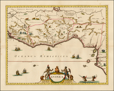
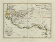
Alain Manesson Mallet's map of the Congo region, first published in Paris in 1683 as part of his magnum opus, "Description de l' Univers," is a striking historical artifact. It not only serves as a testament to Mallet's cartographic skill but also reveals much about European perceptions of West Africa during the 17th century. Although compact in size, the map's intricate detail, accurate for its time, coupled with its decorative elements, make it a valuable piece of historical cartography.
Mallet's map covers the Congo region of West Africa, an area significant in the 17th century due to its extensive trading networks, particularly in ivory and slaves, and the ongoing European exploration of Africa. The Congo River, a crucial waterway for the movement of goods and people, is a central feature of the map, indicating its importance in the regional geography and economic activities.
The attention to detail in Mallet's map reveals an early understanding of the region's physical geography, reflective of the state of European knowledge at the time. The depiction of rivers, coasts, and significant landmarks provides an insight into the information collected by European explorers and traders navigating the region.
"Description de l' Univers," the larger work that this map forms a part of, is widely considered one of the most significant works of its kind from the 17th century. Mallet's monumental undertaking aimed to depict the entire known world, including the peoples, fauna, and flora. The individual maps are renowned for their craftsmanship and the breadth of information they convey.
Alain Mannesson Mallet (1630-1706) was a French mapmaker and engineer who served in the armies of Louis XIV. After rising through the ranks, Mallet was appointed as Inspector of Fortifications, a job which also required mathematical skills and which made him a competent military engineer. Eventually, he joined the court of Louis XIV at Versailles, where he taught math and focused on writing.
Mallet is best known for his Description de L’Univers, first published in 1683, in five volumes. A wide-ranging geographical work, the Description included textual descriptions of the countries of the world, as well as maps of the celestial sky and the ancient and modern worlds. The Description continued to be published until the early eighteenth century. He also published a work in three volumes on warfare (1684) and a primer on geometry (1702).