![(Southeast United States) Carte de la partie sud, des Etats Unis de L' amerique septentrionale [Map of the southern part of the United States of North America] By Rigobert Bonne](https://storage.googleapis.com/raremaps/img/small/98738.jpg)


|
||

|

|
|

|
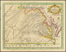
Early Map of the Southeast
Produced by Rigobert Bonne in 1787, Carte de la partie sud, des Etats Unis de L' amerique septentrionale provides a detailed depiction of the Southeast of the newly-formed United States, covering Georgia, the Carolinas, and Virginia. Published only a few years after the conclusion of the American Revolution, Bonne's map illustrates a fledgling South that has yet to expand westward.
The map is perhaps most noteworthy for its eccentric internal borders, which bear precious little relationship to the real outlines of the Southeastern states at the time. South Carolina in particular has an unrecognizable northern border and a southern border that seems inaccurately placed as well. (Augusta sits well into South Carolina?)
The map highlights prominent towns of the late 18th century, such as Charleston, Williamsburg, and Savannah, which were key to trade, politics, and culture. The map also features a plethora of rivers, reflecting their crucial role in commerce, transportation, and settlement during the colonial and early Federal periods, serving as vital conduits for yeoman farmers to transport crops to market and receive goods from ports. These waterways' significance in the development of the South is likely the reason for their detailed illustration.
To the west of the detailed territories, beyond the Appalachian Mountains, the map depicts a vast expanse of undrawn land labeled as "les Cherokees." This label highlights the contemporary situation between the Cherokee Nation and the United States government, which had agreements to respect established territorial boundaries. Historical events such as the War of 1812 and the forced relocation of the Cherokee people during the 1830s, known as the Trail of Tears, indicate that these boundaries were not maintained in the following years.
Rigobert Bonne (1727-1794) was an influential French cartographer of the late-eighteenth century. Born in the Lorraine region of France, Bonne came to Paris to study and practice cartography. He was a skilled cartographer and hydrographer and succeeded Jacques Nicolas Bellin as Royal Hydrographer at the Depot de la Marine in 1773. He published many charts for the Depot, including some of those for the Atlas Maritime of 1762. In addition to his work at the Depot, he is best known for his work on the maps of the Atlas Encyclopedique (1788) which he did with Nicholas Desmarest. He also made the maps for the Abbe Raynals’ famous Atlas de Toutes Les Parties Connues du Globe Terrestre (1780).
More than his individual works, Bonne is also important for the history of cartography because of the larger trends exemplified by his work. In Bonne’s maps, it is possible to see the decisive shift from the elaborate decorations of the seventeenth century and the less ornate, yet still prominent embellishments of the early to mid-eighteenth century. By contrast, Bonne’s work was simple, unadorned, and practical. This aesthetic shift, and the detail and precision of his geography, make Bonne an important figure in mapping history.