|
||

|

|
|

|
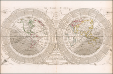
Highlighting The Russian Discoveries in the North Pacific and the Longue River
This 1744 world map highlights the rise of European exploration and cartography that defined the age. The chart is well-informed on contemporary expeditions to both the New World, Africa, and Asia.
A distinguishing feature of this rare first-edition map is its presentation of the Russian discoveries by explorers Tchirkow and Behring along the Northwestern Coast of America. Their inclusion marked an inaugural appearance on such a map. The map diligently charts Russian explorations from the years 1741 to 1743, offering remarkable and largely fanciful depictions of these discoveries.
The map notes the English discoveries in the Vager River in 1742. This is a reference to Christopher Middleton 1741-42 expedition to find the Northwest Passage. Middleton sailed with two ships, the 'Furnace' and the 'Discovery', and reached the Hudson Bay. He explored the bay and the river systems that flowed into it, particularly the Wager River and Repulse Bay. In 1742, Middleton concluded that there was no passage to be found in that area and returned to England.
Turning to the Russian discoveries, the 18th century was a pivotal time for Russian exploration, particularly in the North Pacific region, which involved significant voyages along the Northwest Coast of America and the Northeast Coast of Asia. The expeditions during this time laid the groundwork for Russia's expansion and exploration in these areas. Key figures and expeditions in this era include:
-
Expeditions of Spanberg (1728): Captain Martin Spanberg (or Spangberg) was a Danish navigator in Russian service. In 1728, as part of the First Kamchatka expedition, he, along with Vitus Bering and others, was tasked with exploring the Far East of Russia. Although Bering's voyage in this year is more famous for passing through what would later be known as the Bering Strait, Spanberg's contributions were also crucial in charting parts of the region and laying the groundwork for further Russian exploration in the Pacific.
-
Vitus Bering's Expeditions (1733-1741): Vitus Bering, a Danish explorer in Russian service, led two significant expeditions that greatly impacted Russian exploration. The First Kamchatka Expedition (1725-1730) included the journey in 1728, where Bering confirmed that Asia and America were separate land masses by sailing through the strait that now bears his name. The Second Kamchatka Expedition (1733-1743), often called the Great Northern Expedition, was one of the largest exploration ventures of the 18th century. In 1741, Bering reached the Alaskan coast, thereby establishing Russia's claim to parts of North America.
-
Aleksei Chirikov (Tchirikow) in 1741: Aleksei Chirikov was a Russian navigator and captain who participated in the Second Kamchatka Expedition. In 1741, alongside Bering, he led a vessel that explored the North American coastline. While Bering is often credited with the discovery of Alaska, Chirikov was actually the first Russian to land in North America (in present-day Southeast Alaska) and to have contact with the indigenous people there.
-
Russian Discoveries in 1743: Following the expeditions of Bering and Chirikov, Russian exploration and fur-trading activities continued along the northwest coast of America. In 1743, further expeditions likely included smaller-scale voyages and explorations conducted by Russian promyshlenniki (fur traders) and navigators, extending Russian knowledge of the Pacific Northwest and establishing the groundwork for later Russian settlements in Alaska.
The map showcases the mythical Riviere Longue, first introduced by Lahontan, to show its cutting-edge information. Following the river from Lake Superior to the Pacific Ocean, the mapmaker depicts the prospect of a lake between Lake Superior and the Lake of the Woods (L. des Bois), from which the water flowed in opposite directions (as noted by arrows), joining Lake Superior to the Pacific. A curiously incomplete coastline is shown north of Mendocino, foreshadowing the region which would host the mythical Sea of the West in the following decade.
The map reflects contemporary European knowledge of the East Indies area. New Guinea and an as-yet-undefined eastern coast of Australia are shown. The coasts of the Philippines and Japan (Nipon) are also shown. A nod to William Dampier, the infamous privateer and naturalist, is evident, with the map highlighting his discovery of the maritime route separating New Britain from Papua New Guinea. The legendary "Compagnie Land" is also illustrated north of Japan.
The knowledge of Australia is still largely speculative, although the map adopts a fascinating depiction of the continent similar to that of Bellin and other contemporary mapmakers.
Rarity
The map is extremely rare. This is the first example of this state of the map we have offered.
![(Biogeography) Области распространения сумчатых, жвачных и неполно зубых животных [Distribution Areas of Marsupials, Ruminants, and Toothless Animals]](https://storage.googleapis.com/raremaps/img/small/90268.jpg)
![[ Janet Taylor -- Pioneer English Astronomer and Naval Navigation Expert ] Chart to Accompany R. Russel's Diagram of Great Circles / R. Russel's Diagram of Great Circles](https://storage.googleapis.com/raremaps/img/small/98801.jpg)